IMAGES TAKEN NEAR TO
Poplar Grove, ST. HELENS, WA10 4AW
Introduction
This page details the photographs taken nearby to Poplar Grove, WA10 4AW by members of the Geograph project.
The Geograph project started in 2005 with the aim of publishing, organising and preserving representative images for every square kilometre of Great Britain, Ireland and the Isle of Man.

There are currently over 7.5m images from over14,400 individuals and you can help contribute to the project by visiting https://www.geograph.org.uk
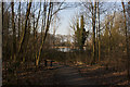
Image Map
Images are licensed for reuse under creativecommons.org/licenses/by-sa/2.0
Notes
- Clicking on the map will re-center to the selected point.
- The higher the marker number, the further away the image location is from the centre of the postcode.
Image Listing (29 Images Found)
Images are licensed for reuse under creativecommons.org/licenses/by-sa/2.0
Image
Details
Distance
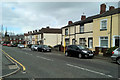
1

Terraced Housing on Dunriding Lane, St Helens
Image: © David Dixon
Taken: 24 Mar 2019
0.08 miles
4
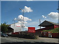
St Helens RFC, Knowsley Road
St Helen's Rugby League Football Club's stadium in Knowsley Road, opened its gates in 1890 has a capacity of 17,500. The highest attendance at the stadium was 36,695 on 26th December 1949 during a game against Wigan. Founded in 1873, The "Saints" is one of the world's most famous rugby clubs.
Image: © Sue Adair
Taken: 19 Jul 2007
0.14 miles
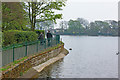
5
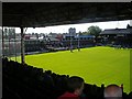
One of the last training sessions at the old ground
Knowsley Road (latterly re-named The GPW Recruitment Stadium) has been the home of St Helens RLFC since 1890. The final season finished in Sept 2010 and the club will play all of their "home" games at Widnes in 2011 before moving to the new stadium for the 2012 season. This image shows one of the final training sessions at Knowsley Road, open to the public on this occasion. On the skyline is another well known St Helens landmark, Pilkingtons Head Office.
Image: © Roy Prescott
Taken: 30 Aug 2010
0.14 miles
6
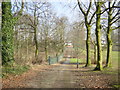
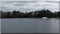
Chain Walk, Taylor Park
Chain Walk, at the rear of Taylor Park between Big Dam and Bottom Dam.
Image: © Sue Adair
Taken: 18 Feb 2006
0.15 miles
7
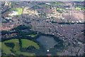
Big Dam, Taylor Park, St Helens, from the air
Taken from a plane on approach to Liverpool John Lennon Airport.
Image: © Mike Pennington
Taken: 5 Jul 2016
0.16 miles