IMAGES TAKEN NEAR TO
The Boulevard, ST. HELENS, WA10 3UY
Introduction
This page details the photographs taken nearby to The Boulevard, WA10 3UY by members of the Geograph project.
The Geograph project started in 2005 with the aim of publishing, organising and preserving representative images for every square kilometre of Great Britain, Ireland and the Isle of Man.

There are currently over 7.5m images from over14,400 individuals and you can help contribute to the project by visiting https://www.geograph.org.uk
Image Map
Images are licensed for reuse under creativecommons.org/licenses/by-sa/2.0
Notes
- Clicking on the map will re-center to the selected point.
- The higher the marker number, the further away the image location is from the centre of the postcode.
Image Listing (3 Images Found)
Images are licensed for reuse under creativecommons.org/licenses/by-sa/2.0
Image
Details
Distance
1
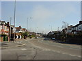
Prescot Road, St Helens
Looking east down Prescot Road towards Toll Bar, St Helens from near to Carmel College. The chimneys of Ravenhead Glass Works clearly visible in the background.
Image: © Sue Adair
Taken: 18 Feb 2006
0.23 miles
3
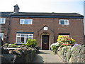
Cottage on Prescot Road, Portico
Richard John Seddon (sometimes known as King Dick) was the longest serving Prime Minister of New Zealand from 1893 to his death at sea in 1906. He was born in this cottage in 1845 to the local grammar school headmaster and a teacher but showed little aptitude at school and had only menial jobs before emigrating to Australia aged eighteen.
More info: http://www.dnzb.govt.nz/dnzb/default.asp?Find_Quick.asp?PersonEssay=2S11
Image: © Sue Adair
Taken: 14 Apr 2007
0.23 miles