IMAGES TAKEN NEAR TO
Upland Road, ST. HELENS, WA10 3SG
Introduction
This page details the photographs taken nearby to Upland Road, WA10 3SG by members of the Geograph project.
The Geograph project started in 2005 with the aim of publishing, organising and preserving representative images for every square kilometre of Great Britain, Ireland and the Isle of Man.

There are currently over 7.5m images from over14,400 individuals and you can help contribute to the project by visiting https://www.geograph.org.uk
Image Map
Images are licensed for reuse under creativecommons.org/licenses/by-sa/2.0
Notes
- Clicking on the map will re-center to the selected point.
- The higher the marker number, the further away the image location is from the centre of the postcode.
Image Listing (15 Images Found)
Images are licensed for reuse under creativecommons.org/licenses/by-sa/2.0
Image
Details
Distance
1
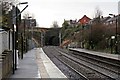
End of platform, Thatto Heath railway station
Looking in the direction of Liverpool, towards the Scholes Lane tunnel. A pair of new catenary masts have been erected, for the electrification of the Liverpool to Wigan line, in 2014.
Image: © El Pollock
Taken: 30 Dec 2013
0.20 miles
2
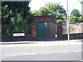
Behind Bars
Substation on Thatto Heath Road.
Image: © J Scott
Taken: 8 Sep 2006
0.21 miles
3
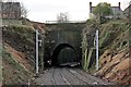
Scholes Lane tunnel, Thatto Heath railway station
Situated at the western end of the station. A pair of new catenary masts have been erected, prior to the electrification of the Liverpool to Wigan line, in 2014.
Image: © El Pollock
Taken: 30 Dec 2013
0.21 miles
4
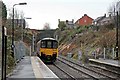
Northern Rail Class 150, 150113, Thatto Heath railway station
The train departs towards Liverpool, before entering the Scholes Lane tunnel.
Image: © El Pollock
Taken: 30 Dec 2013
0.21 miles
5
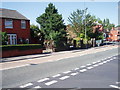
Green for go
Lugsmore Lane approaching junction with Leslie Road.
Image: © J Scott
Taken: 8 Sep 2006
0.21 miles
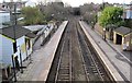
6

Thatto Heath railway station, Merseyside
Opened in 1872 by the London & North Western Railway on the line from Liverpool Lime Street to Wigan.
View south east towards Eccleston Park and Liverpool shortly after electrification. For a similar view six years earlier, see Image
Image: © Nigel Thompson
Taken: 10 Nov 2015
0.22 miles
7
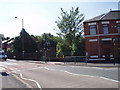
Traffic Control
Lugsmore Lane changes to Thatto Heath Road at the traffic lights adjacent to Leslie Road junction.
Image: © J Scott
Taken: 8 Sep 2006
0.22 miles
8
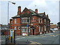
The Springfield pub Thatto Heath
Near Thatto Heath railway station.
Image: © JThomas
Taken: 13 Sep 2014
0.23 miles
9
Thatto Heath railway station, Merseyside, 2009
Opened in 1872 by the London & North Western Railway on the line from Liverpool Lime Street to Wigan.
View south east towards Eccleston Park and Liverpool before the line was electrified. For a similar view six years later, see Image
Image: © Nigel Thompson
Taken: 31 Dec 2009
0.23 miles
10
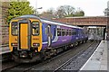
Northern Rail Class 156, 156483, Thatto Heath railway station
The rear of the train is seen departing beneath the Thatto Heath Road bridge, with a service towards St. Helens.
Image: © El Pollock
Taken: 30 Dec 2013
0.23 miles