IMAGES TAKEN NEAR TO
Yorkshire Gardens, ST. HELENS, WA10 3JZ
Introduction
This page details the photographs taken nearby to Yorkshire Gardens, WA10 3JZ by members of the Geograph project.
The Geograph project started in 2005 with the aim of publishing, organising and preserving representative images for every square kilometre of Great Britain, Ireland and the Isle of Man.

There are currently over 7.5m images from over14,400 individuals and you can help contribute to the project by visiting https://www.geograph.org.uk
Image Map
Images are licensed for reuse under creativecommons.org/licenses/by-sa/2.0
Notes
- Clicking on the map will re-center to the selected point.
- The higher the marker number, the further away the image location is from the centre of the postcode.
Image Listing (20 Images Found)
Images are licensed for reuse under creativecommons.org/licenses/by-sa/2.0
Image
Details
Distance
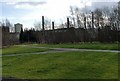
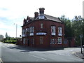
1
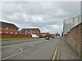
Canal Street
The road is on the route of the former canal to Ravenhead
Image: © Kevin Waterhouse
Taken: 7 Feb 2025
0.04 miles
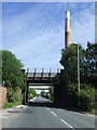
5
Factory Chimneys
Factory chimneys at the rear of Pilkington's glass works
Image: © Galatas
Taken: 7 Feb 2008
0.14 miles
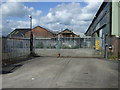
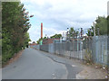
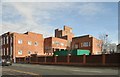
6
Derelict factory on Burtonwood Road
Pilkington's chimneys tower in background
Image: © Raymond Knapman
Taken: 11 Aug 2010
0.14 miles
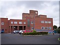
10
Reflection Court
Reflection Court (rear) Canal St
Image: © Galatas
Taken: 7 Feb 2008
0.17 miles