IMAGES TAKEN NEAR TO
Lugsmore Lane, ST. HELENS, WA10 3DJ
Introduction
This page details the photographs taken nearby to Lugsmore Lane, WA10 3DJ by members of the Geograph project.
The Geograph project started in 2005 with the aim of publishing, organising and preserving representative images for every square kilometre of Great Britain, Ireland and the Isle of Man.

There are currently over 7.5m images from over14,400 individuals and you can help contribute to the project by visiting https://www.geograph.org.uk
Image Map
Images are licensed for reuse under creativecommons.org/licenses/by-sa/2.0
Notes
- Clicking on the map will re-center to the selected point.
- The higher the marker number, the further away the image location is from the centre of the postcode.
Image Listing (19 Images Found)
Images are licensed for reuse under creativecommons.org/licenses/by-sa/2.0
Image
Details
Distance
1
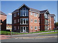
Property Development
Newly built apartments flats Thatto Heath Road.
Image: © J Scott
Taken: 8 Sep 2006
0.01 miles
2
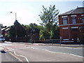
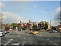
Traffic Control
Lugsmore Lane changes to Thatto Heath Road at the traffic lights adjacent to Leslie Road junction.
Image: © J Scott
Taken: 8 Sep 2006
0.02 miles
3
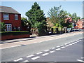
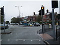
Green for go
Lugsmore Lane approaching junction with Leslie Road.
Image: © J Scott
Taken: 8 Sep 2006
0.04 miles
4
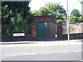
Behind Bars
Substation on Thatto Heath Road.
Image: © J Scott
Taken: 8 Sep 2006
0.05 miles
5
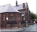
Toll Bar, junction of Thatto Heath Road with Prescot Road
Houses of an unusual architectural style at the junction of Prescot Road with Thatto Heath Road. The Toll Bar was situated on Prescot Road and typical rates charged were: horses carrying coals a halfpenny, other horses one penny and sheep one farthing.
Image: © Sue Adair
Taken: 18 Feb 2006
0.14 miles
8
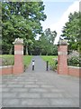
St Helens, gateway
To Taylor Park, on Prescot Road: https://www.sthelens.gov.uk/media/2424/1300721_parks_for_life_taylor.pdf
Image: © Mike Faherty
Taken: 31 Jul 2017
0.15 miles
9
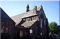
St John the Evangelist, Ravenhead, St Helens
Consecrated 27 December 1869. Architect J Medland Taylor.
Image: © S Parish
Taken: 27 Jul 2006
0.15 miles
10
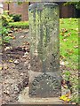
Old Milestone by entrance to Taylor Park, St Helens
St Helens Stone in parish of St Helens (St Helens District), formerly located close to the corner of Croppers' Hill and Bank Street, opposite Croppers' Hill Houses, St Helens, now at entrance to Taylor Park, St Helens.
Out of place - in public view
Taylor Park is Grade II Listed. List Entry Number: 1001632
https://historicengland.org.uk/listing/the-list/list-entry/1001632
Milestone Society National ID: LA_ASLV06
Image: © Milestone Society
Taken: Unknown
0.15 miles