IMAGES TAKEN NEAR TO
Simmons Close, ST. HELENS, WA10 2UQ
Introduction
This page details the photographs taken nearby to Simmons Close, WA10 2UQ by members of the Geograph project.
The Geograph project started in 2005 with the aim of publishing, organising and preserving representative images for every square kilometre of Great Britain, Ireland and the Isle of Man.

There are currently over 7.5m images from over14,400 individuals and you can help contribute to the project by visiting https://www.geograph.org.uk
Image Map
Images are licensed for reuse under creativecommons.org/licenses/by-sa/2.0
Notes
- Clicking on the map will re-center to the selected point.
- The higher the marker number, the further away the image location is from the centre of the postcode.
Image Listing (9 Images Found)
Images are licensed for reuse under creativecommons.org/licenses/by-sa/2.0
Image
Details
Distance
1
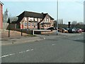
BOC Tradequip, St Helens
BOC Tradequip gas manufacturing plant in City Road, St Helens.
Image: © Sue Adair
Taken: 19 Jul 2007
0.05 miles
3
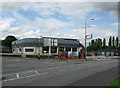
Ford Showroom Closed Down
This ford dealership stood at the junction of Hard Lane and Washway Lane for as long as I can remember (at least 30 years). The dealership has now relocated to the South side of town. Not sure what will become of this site.
Image: © Gary Rogers
Taken: 9 Aug 2009
0.09 miles
4
Changing landscape near Green Leach, St Helens
For many years this was a main Ford dealership. Now it is all but erased.
Image: © Ian Greig
Taken: 6 Feb 2010
0.10 miles
8
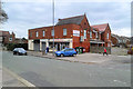
Schooner Wines
Off-licence on Hard Lane.
Image: © David Dixon
Taken: 31 Mar 2019
0.18 miles
9
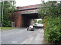
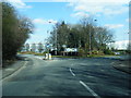
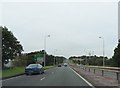
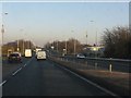
Scafell Road, along the old railway line.
This road runs along part of the disused railway line from St Helens to Ormskirk via Rainford. The line closed as a through route in 1964 though some trains still ran on this stretch until 1967, between Old Mill Lane and Pilkington sidings. Scafell Road runs under the A580 East Lancs Road at this point. It provides a much safer road route between St Helens and Moss Bank than the hazardous junction 1/3km to the west.
The Moss Bank pub can be seen in the far distance, also at Image, marking the location of the former Moss Bank station and level crossing.
Image: © Roy Prescott
Taken: 12 Aug 2006
0.24 miles