IMAGES TAKEN NEAR TO
Albion Street, ST. HELENS, WA10 2HA
Introduction
This page details the photographs taken nearby to Albion Street, WA10 2HA by members of the Geograph project.
The Geograph project started in 2005 with the aim of publishing, organising and preserving representative images for every square kilometre of Great Britain, Ireland and the Isle of Man.

There are currently over 7.5m images from over14,400 individuals and you can help contribute to the project by visiting https://www.geograph.org.uk
Image Map
Images are licensed for reuse under creativecommons.org/licenses/by-sa/2.0
Notes
- Clicking on the map will re-center to the selected point.
- The higher the marker number, the further away the image location is from the centre of the postcode.
Image Listing (14 Images Found)
Images are licensed for reuse under creativecommons.org/licenses/by-sa/2.0
Image
Details
Distance
1
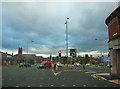
Road Junction
Of Eccleston Street,Croppers Hill and Westfield Street.
Image: © Alexander P Kapp
Taken: 26 Jan 2011
0.11 miles
5
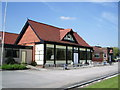
The Sportsman's Bar, Ruskin Drive Leisure Centre
Image: © Alexander P Kapp
Taken: 30 Apr 2007
0.16 miles
6
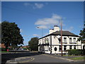
The Cricketers' Arms
The Cricketers' Arms in Peter Street.
Image: © Sue Adair
Taken: 9 Sep 2009
0.17 miles
8
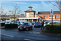
Morrisons
Just off Liverpool Road, St Helens.
Image: © Ian Greig
Taken: 6 Feb 2010
0.20 miles
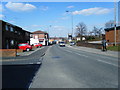
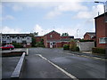
9
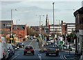
Approaching St. Helens, Westfield St
Approaching St. Helens, bottom of Croppers Hill entering Westfield St
Image: © Galatas
Taken: 7 Feb 2008
0.21 miles
10
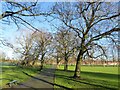
Queen's Park
One of the main paths that leads to the site of a former bandstand from Horace Street
Image: © Kevin Waterhouse
Taken: 2 Jan 2025
0.22 miles