IMAGES TAKEN NEAR TO
Vincent Street, ST. HELENS, WA10 1LB
Introduction
This page details the photographs taken nearby to Vincent Street, WA10 1LB by members of the Geograph project.
The Geograph project started in 2005 with the aim of publishing, organising and preserving representative images for every square kilometre of Great Britain, Ireland and the Isle of Man.

There are currently over 7.5m images from over14,400 individuals and you can help contribute to the project by visiting https://www.geograph.org.uk
Image Map
Images are licensed for reuse under creativecommons.org/licenses/by-sa/2.0
Notes
- Clicking on the map will re-center to the selected point.
- The higher the marker number, the further away the image location is from the centre of the postcode.
Image Listing (40 Images Found)
Images are licensed for reuse under creativecommons.org/licenses/by-sa/2.0
Image
Details
Distance
1
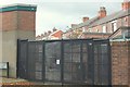
Gated alley near Woodville Street, St. helens
Image: © Gary Rogers
Taken: 10 Oct 2014
0.14 miles
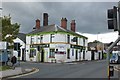
3
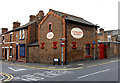
Lievesleys Bakery since 1925
Charles Street, St Helens
Image: © Gary Rogers
Taken: 18 Oct 2009
0.15 miles
6
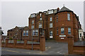
Providence Free Hospital, Tolver Street St Helens
Now occupied by Arena Housing
Image: © Gary Rogers
Taken: 18 Oct 2009
0.18 miles
8
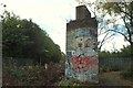
Graffiti on dismantled railway bridge near Fosters Park, St Helens
Image: © Gary Rogers
Taken: 10 Oct 2014
0.19 miles
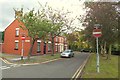
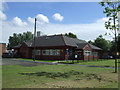
9
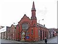
St Helens - Baptist Church on Hall Street
Image: © Dave Bevis
Taken: 24 Feb 2014
0.19 miles
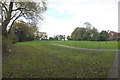
10
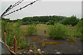
Abandoned industrial site
Nature is slowly reclaiming this abandoned industrial site in St Helens.
Image: © Gary Rogers
Taken: 31 Jul 2008
0.20 miles