IMAGES TAKEN NEAR TO
Hardshaw Street, ST. HELENS, WA10 1JT
Introduction
This page details the photographs taken nearby to Hardshaw Street, WA10 1JT by members of the Geograph project.
The Geograph project started in 2005 with the aim of publishing, organising and preserving representative images for every square kilometre of Great Britain, Ireland and the Isle of Man.

There are currently over 7.5m images from over14,400 individuals and you can help contribute to the project by visiting https://www.geograph.org.uk
Image Map
Images are licensed for reuse under creativecommons.org/licenses/by-sa/2.0
Notes
- Clicking on the map will re-center to the selected point.
- The higher the marker number, the further away the image location is from the centre of the postcode.
Image Listing (36 Images Found)
Images are licensed for reuse under creativecommons.org/licenses/by-sa/2.0
Image
Details
Distance
2
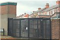
Gated alley near Woodville Street, St. helens
Image: © Gary Rogers
Taken: 10 Oct 2014
0.16 miles
3
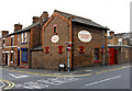
Lievesleys Bakery since 1925
Charles Street, St Helens
Image: © Gary Rogers
Taken: 18 Oct 2009
0.17 miles
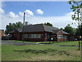
5

Convenience store and Post Office
On College Road.
Image: © JThomas
Taken: 5 Jun 2014
0.17 miles
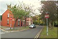
6

College Street, St Helens (A571)
Heading south.
Image: © JThomas
Taken: 5 Jun 2014
0.17 miles
10
No more pies
Pimblett's pie shop on College Street St. Helens, now closed down.
Image: © Gary Rogers
Taken: 3 Aug 2009
0.18 miles