IMAGES TAKEN NEAR TO
Newdigate Road, UXBRIDGE, UB9 6EH
Introduction
This page details the photographs taken nearby to Newdigate Road, UB9 6EH by members of the Geograph project.
The Geograph project started in 2005 with the aim of publishing, organising and preserving representative images for every square kilometre of Great Britain, Ireland and the Isle of Man.

There are currently over 7.5m images from over14,400 individuals and you can help contribute to the project by visiting https://www.geograph.org.uk
Image Map
Images are licensed for reuse under creativecommons.org/licenses/by-sa/2.0
Notes
- Clicking on the map will re-center to the selected point.
- The higher the marker number, the further away the image location is from the centre of the postcode.
Image Listing (121 Images Found)
Images are licensed for reuse under creativecommons.org/licenses/by-sa/2.0
Image
Details
Distance
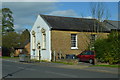
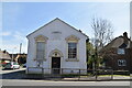
1
Harefield Baptist Chapel
The Baptist church in Harefield was founded in 1834. The church was built in 1834 by one John Bailey, a 'benevolent and eccentric member of the Society of Friends', who had been much impressed by the dissolute Sunday habits of the village youth.
Image: © John Barrett
Taken: 3 Mar 2010
0.06 miles

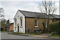
6
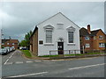
Harefield Baptist Church, Harefield
Image: © Alexander P Kapp
Taken: 16 Jul 2012
0.08 miles
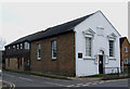
7
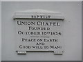
Harefield Baptist Church, Harefield, Date-stone
Image: © Alexander P Kapp
Taken: 16 Jul 2012
0.08 miles
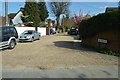
8
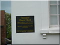
Harefield Baptist Church, Harefield, Nameboard
Image: © Alexander P Kapp
Taken: 16 Jul 2012
0.08 miles