IMAGES TAKEN NEAR TO
Dellside, UXBRIDGE, UB9 6AX
Introduction
This page details the photographs taken nearby to Dellside, UB9 6AX by members of the Geograph project.
The Geograph project started in 2005 with the aim of publishing, organising and preserving representative images for every square kilometre of Great Britain, Ireland and the Isle of Man.

There are currently over 7.5m images from over14,400 individuals and you can help contribute to the project by visiting https://www.geograph.org.uk
Image Map
Images are licensed for reuse under creativecommons.org/licenses/by-sa/2.0
Notes
- Clicking on the map will re-center to the selected point.
- The higher the marker number, the further away the image location is from the centre of the postcode.
Image Listing (111 Images Found)
Images are licensed for reuse under creativecommons.org/licenses/by-sa/2.0
Image
Details
Distance
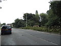
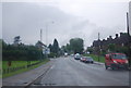
1
Trees on recreation ground
Seen across Moorhall Road
Image: © David Martin
Taken: 2 Nov 2020
0.07 miles
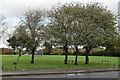
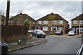
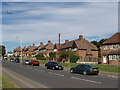
3
Moorhall Road in South Harefield
Rubbish collection day on a very wet day.
Image: © James Emmans
Taken: 30 Jul 2019
0.09 miles
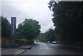
6
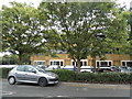
Widewater Place business park on Moorhall Road
Image: © David Howard
Taken: 26 Aug 2014
0.10 miles
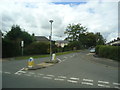
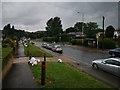
8
Moorhall Road, South Harefield
A row of houses on the road up from the canal.
Image: © David Hawgood
Taken: 19 Jun 2005
0.10 miles