IMAGES TAKEN NEAR TO
Rockingham Road, UXBRIDGE, UB8 2UH
Introduction
This page details the photographs taken nearby to Rockingham Road, UB8 2UH by members of the Geograph project.
The Geograph project started in 2005 with the aim of publishing, organising and preserving representative images for every square kilometre of Great Britain, Ireland and the Isle of Man.

There are currently over 7.5m images from over14,400 individuals and you can help contribute to the project by visiting https://www.geograph.org.uk
Image Map
Images are licensed for reuse under creativecommons.org/licenses/by-sa/2.0
Notes
- Clicking on the map will re-center to the selected point.
- The higher the marker number, the further away the image location is from the centre of the postcode.
Image Listing (174 Images Found)
Images are licensed for reuse under creativecommons.org/licenses/by-sa/2.0
Image
Details
Distance
2
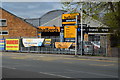
Rockingham Wharf
The canal-side building is a very considerable architectural advance on the other industrial buildings on this site. Although mapped as Rockingham Wharf, the lifebelt on the far wall appears to have 'Popes Quay' on it.
Image: © Robin Webster
Taken: 21 Jul 2013
0.02 miles

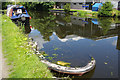
5
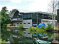
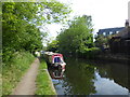
Grand Union Canal near Rockingham Road
Image: © Andrew Curtis
Taken: 19 Apr 2019
0.03 miles
6
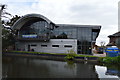
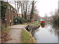
The Grand Union Canal near Uxbridge
This section of the Grand Union Canal from the River Thames at Brentford was opened in 1794. It was the first section of what was originally called the Grand Junction Canal. Its purpose was to provide a new, shorter and quicker transport route between London and Birmingham by connecting with a network of canals at Braunston near Daventry. When the canal reached Braunston in 1805 it cut 60 miles off the shortest alternative route.
This is just north of St John's Road. As you head out of Uxbridge there is much quiet countryside until Rickmansworth is reached. This part of the towpath is also on the London LOOP.
Image: © Marathon
Taken: 22 May 2019
0.03 miles
7
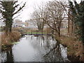
Spillway from canal to River Colne in Uxbridge
There are several waterways running down the wide valley which was the course of The Thames before the last ice age. The Grand Union Canal cuts across them in several places. Here water is taken from the canal to feed a branch of the Colne.
Image: © David Hawgood
Taken: 31 Dec 2008
0.03 miles
8
Towpath bridge over spillway entrance
The bridge is over the spillway shown in Image
Image: © David Hawgood
Taken: 31 Dec 2008
0.03 miles
9
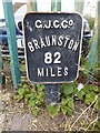
Old milemarker by the Grand Union Canal, Uxbridge Moor
Milemarker by the Grand Union Canal, (Hillingdon District), Uxbridge Moor, 50m North of Rock Road Bridge.
Inscription reads:-
G.J.C.C⁰.
BRAUNSTON
82
MILES
Surveyed
Milestone Society National ID: GUC-82
Image: © Milestone Society
Taken: Unknown
0.04 miles
10
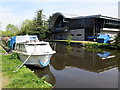
Grand Union Canal, Uxbridge
The vessel in the foreground has clearly seen better days.
Image: © Stephen McKay
Taken: 15 Aug 2017
0.04 miles