IMAGES TAKEN NEAR TO
Whitebeam Close, UXBRIDGE, UB8 2AH
Introduction
This page details the photographs taken nearby to Whitebeam Close, UB8 2AH by members of the Geograph project.
The Geograph project started in 2005 with the aim of publishing, organising and preserving representative images for every square kilometre of Great Britain, Ireland and the Isle of Man.

There are currently over 7.5m images from over14,400 individuals and you can help contribute to the project by visiting https://www.geograph.org.uk
Image Map
Images are licensed for reuse under creativecommons.org/licenses/by-sa/2.0
Notes
- Clicking on the map will re-center to the selected point.
- The higher the marker number, the further away the image location is from the centre of the postcode.
Image Listing (186 Images Found)
Images are licensed for reuse under creativecommons.org/licenses/by-sa/2.0
Image
Details
Distance
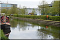
3
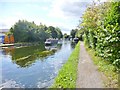
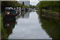
Uxbridge, Grand Union Canal
Moorings in the distance, and "Nimfa" approaching. https://canalrivertrust.org.uk/canals-and-rivers/grand-union-canal
Image: © Mike Faherty
Taken: 16 Aug 2014
0.07 miles
4
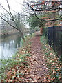
Off-road cycle route by Frays River
It is alongside Fassnidge Park.
Image: © David Hawgood
Taken: 31 Dec 2008
0.07 miles
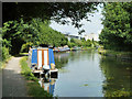
6
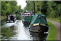
Narrowboats along the Grand Union Canal in Uxbridge
Image: © Mat Fascione
Taken: 21 Aug 2015
0.07 miles
8
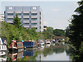
The Grand Union Canal south of Oxford Road, Uxbridge
Image: © Mike Quinn
Taken: 5 Jul 2017
0.07 miles
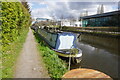
10
Grand Union Canal, Uxbridge
Between bridges 185 and 186.
Image: © Robin Webster
Taken: 21 Jul 2013
0.08 miles