IMAGES TAKEN NEAR TO
Lodore Green, UXBRIDGE, UB10 8BQ
Introduction
This page details the photographs taken nearby to Lodore Green, UB10 8BQ by members of the Geograph project.
The Geograph project started in 2005 with the aim of publishing, organising and preserving representative images for every square kilometre of Great Britain, Ireland and the Isle of Man.

There are currently over 7.5m images from over14,400 individuals and you can help contribute to the project by visiting https://www.geograph.org.uk
Image Map
Images are licensed for reuse under creativecommons.org/licenses/by-sa/2.0
Notes
- Clicking on the map will re-center to the selected point.
- The higher the marker number, the further away the image location is from the centre of the postcode.
Image Listing (13 Images Found)
Images are licensed for reuse under creativecommons.org/licenses/by-sa/2.0
Image
Details
Distance
2
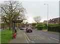
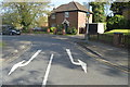
Bus stop and shelter on Swakeleys Road, Ickenham
Looking south west.
Image: © JThomas
Taken: 13 Apr 2019
0.07 miles
3
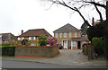
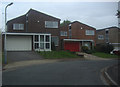
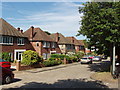
Highfield Drive
Detached houses with a lot a major redevelopments going on in street.
Image: © James Emmans
Taken: 30 Jul 2019
0.08 miles

9
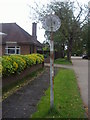
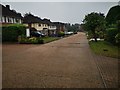
Early pre-Worboys speed limit, Highfield Drive, Ickenham
The catseyes date it from before the early 1950s and is the only one I've so far come across surviving on an existing speed limit.
Image: © David Howard
Taken: 13 Oct 2010
0.17 miles
10
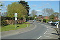
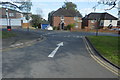
Swakeleys Road, Ickenham
This is near the junction with Breakspear Road
Image: © David Hawgood
Taken: 19 Jun 2005
0.22 miles