IMAGES TAKEN NEAR TO
TW8 8FW
Introduction
This page details the photographs taken nearby to TW8 8FW by members of the Geograph project.
The Geograph project started in 2005 with the aim of publishing, organising and preserving representative images for every square kilometre of Great Britain, Ireland and the Isle of Man.

There are currently over 7.5m images from over14,400 individuals and you can help contribute to the project by visiting https://www.geograph.org.uk
Image Map
Images are licensed for reuse under creativecommons.org/licenses/by-sa/2.0
Notes
- Clicking on the map will re-center to the selected point.
- The higher the marker number, the further away the image location is from the centre of the postcode.
Image Listing (431 Images Found)
Images are licensed for reuse under creativecommons.org/licenses/by-sa/2.0
Image
Details
Distance

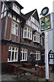
4
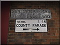
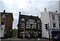
Old council signs on Boars Head Yard
The sign above is far older and probably as old as the building, while the one below is from around the 1950s or so. This is actually a footpath not a road.
Image: © David Howard
Taken: 25 Jan 2014
0.02 miles