IMAGES TAKEN NEAR TO
Stroude Road, EGHAM, TW20 9UR
Introduction
This page details the photographs taken nearby to Stroude Road, TW20 9UR by members of the Geograph project.
The Geograph project started in 2005 with the aim of publishing, organising and preserving representative images for every square kilometre of Great Britain, Ireland and the Isle of Man.

There are currently over 7.5m images from over14,400 individuals and you can help contribute to the project by visiting https://www.geograph.org.uk
Image Map
Images are licensed for reuse under creativecommons.org/licenses/by-sa/2.0
Notes
- Clicking on the map will re-center to the selected point.
- The higher the marker number, the further away the image location is from the centre of the postcode.
Image Listing (21 Images Found)
Images are licensed for reuse under creativecommons.org/licenses/by-sa/2.0
Image
Details
Distance
1

Great Fosters Japanese Bridge over Ancient U shaped Moat
The Moat was to protect the house from the starving thieves from helping themselves to food and royal property. It's history goes back a very long way to 500 AD!
https://en.wikipedia.org/wiki/Great_Fosters
Image: © James Emmans
Taken: 18 Feb 2020
0.03 miles
2

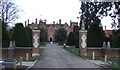
Entrance to Great Fosters
Great Fosters was built sometime between 1550 and 1600 as a residence for Sir John Dodderidge, who was a judge during the reign of James I. It was later used as a lunatic asylum in the C19 and is now a hotel.
Image: © Bikeboy
Taken: 13 Jul 2014
0.04 miles
3
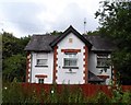
Foster Court Lodge
The date plaque on the gable is 1887.
Image: © Bikeboy
Taken: 13 Jul 2014
0.08 miles
5
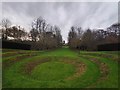
Great Fosters Amphitheatre and Avenue
The grounds were reduced in size when land was sold for the building of the M25 Motorway in the 1970's. The amphitheatre and avenue are modern additions.
https://en.wikipedia.org/wiki/Avenue_(landscape)
Image: © James Emmans
Taken: 18 Feb 2020
0.14 miles
6
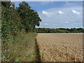
Field edge footpath
The footpath runs along the edge of the crop line between the Stroude Road and the Thorpe by-pass.
Image: © Alan Hunt
Taken: 3 Aug 2012
0.18 miles
7

Borough of Runnymede : M25 Motorway
Heading along the M25 between Junction 13 (Runnymede) and Junction 12 (Thorpe Interchange).
Image: © Lewis Clarke
Taken: 19 Mar 2019
0.21 miles
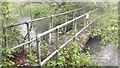
8
Footbridge over the drain
A narrow footbridge crossing the drain that runs near to the M25. The footpath itself is narrow and disappears into the undergrowth in several places.
Image: © Alan Hunt
Taken: 3 Aug 2012
0.21 miles
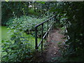
9
Footbridge over Ditch near the M25
Rearly used footpath. The stream feeds the ancient moat at Great Fosters.
Image: © James Emmans
Taken: 11 May 2016
0.22 miles