IMAGES TAKEN NEAR TO
Whitehall Lane, EGHAM, TW20 9TP
Introduction
This page details the photographs taken nearby to Whitehall Lane, TW20 9TP by members of the Geograph project.
The Geograph project started in 2005 with the aim of publishing, organising and preserving representative images for every square kilometre of Great Britain, Ireland and the Isle of Man.

There are currently over 7.5m images from over14,400 individuals and you can help contribute to the project by visiting https://www.geograph.org.uk
Image Map
Images are licensed for reuse under creativecommons.org/licenses/by-sa/2.0
Notes
- Clicking on the map will re-center to the selected point.
- The higher the marker number, the further away the image location is from the centre of the postcode.
Image Listing (36 Images Found)
Images are licensed for reuse under creativecommons.org/licenses/by-sa/2.0
Image
Details
Distance
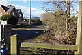
1
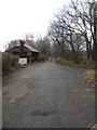
Whitehall Lane, Egham
This leads to the farms in the fields to the south of the road
Image: © David Howard
Taken: 14 Dec 2014
0.02 miles
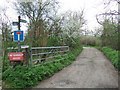

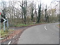
5
Prune Hill
The junction of Whitehall Lane, the footpath from Stroude, with Prune Hill.
Image: © Alan Hunt
Taken: 11 May 2012
0.04 miles
7
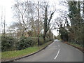
Whitehall Lane, Egham
You can just see the research laboratory on the right
Image: © David Howard
Taken: 14 Dec 2014
0.04 miles
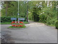
9
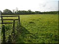
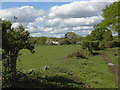
Egham: Footpath from Prune Hill to Stroude Road
This is viewed looking south-eastwards towards Stroude Road.
Image: © Nigel Cox
Taken: 22 May 2016
0.11 miles
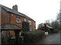
10
Crown Cottages
Crown Cottages from Whitehall Lane footpath.
Image: © Alan Hunt
Taken: 11 May 2012
0.12 miles