IMAGES TAKEN NEAR TO
Queens Road, EGHAM, TW20 9RT
Introduction
This page details the photographs taken nearby to Queens Road, TW20 9RT by members of the Geograph project.
The Geograph project started in 2005 with the aim of publishing, organising and preserving representative images for every square kilometre of Great Britain, Ireland and the Isle of Man.

There are currently over 7.5m images from over14,400 individuals and you can help contribute to the project by visiting https://www.geograph.org.uk
Image Map
Images are licensed for reuse under creativecommons.org/licenses/by-sa/2.0
Notes
- Clicking on the map will re-center to the selected point.
- The higher the marker number, the further away the image location is from the centre of the postcode.
Image Listing (79 Images Found)
Images are licensed for reuse under creativecommons.org/licenses/by-sa/2.0
Image
Details
Distance


7
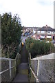
Looking west down steps from railway footbridge
Image: © Shazz
Taken: 21 Feb 2015
0.06 miles
8

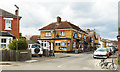
PH on North Street
The names shown are "Foresters Arms" and "Foresters Pub".
Image: © Shazz
Taken: 21 Feb 2015
0.06 miles
9

North Street, Egham
The view of North Street from the footbridge over the railway lines. Rushenden Road runs off to the right in the foreground.
Image: © Alan Hunt
Taken: 19 Sep 2012
0.07 miles
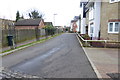
10
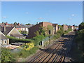
Railway, Egham
Looking along the tracks towards Egham station from the bridge on the footpath from Whitehall Lane. The properties on the left are on Rushenden Road.
Image: © Alan Hunt
Taken: 19 Sep 2012
0.08 miles