IMAGES TAKEN NEAR TO
Manorcrofts Road, EGHAM, TW20 9LX
Introduction
This page details the photographs taken nearby to Manorcrofts Road, TW20 9LX by members of the Geograph project.
The Geograph project started in 2005 with the aim of publishing, organising and preserving representative images for every square kilometre of Great Britain, Ireland and the Isle of Man.

There are currently over 7.5m images from over14,400 individuals and you can help contribute to the project by visiting https://www.geograph.org.uk
Image Map
Images are licensed for reuse under creativecommons.org/licenses/by-sa/2.0
Notes
- Clicking on the map will re-center to the selected point.
- The higher the marker number, the further away the image location is from the centre of the postcode.
Image Listing (41 Images Found)
Images are licensed for reuse under creativecommons.org/licenses/by-sa/2.0
Image
Details
Distance
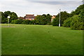
2
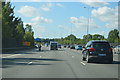
M25 clockwise
Passing fencing protecting the citizens of Egham from excessive noise.
Image: © Robin Webster
Taken: 9 Dec 2017
0.14 miles
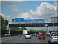
3
M25 two thirds of a mile to Junction 13
I wonder why a more obscure fraction of a mile is used?
Image: © Julian P Guffogg
Taken: 7 Aug 2013
0.14 miles
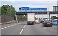
4
M25 Motorway Clockwise. Approaching Junction 13 For A30
Image: © Roy Hughes
Taken: 28 Apr 2009
0.15 miles
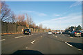
5
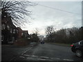
Whitehall Lane at the junction of Manorcrofts Road
Image: © David Howard
Taken: 14 Dec 2014
0.15 miles

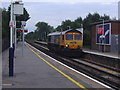
10
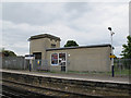
Egham station: substation
The electrical substation is in the old Southern Railway style.
Image: © Stephen Craven
Taken: 25 May 2015
0.17 miles