1
Marchamont House
Old Georgian mansion on the eastern end of Egham's High Street, now seeking a new office occupier.
http://www.egham.co.uk/
Image: © Colin Smith
Taken: 20 Sep 2009
0.02 miles
2
The White Lion, Egham
Image: © Bikeboy
Taken: 13 Jul 2014
0.02 miles
3
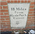
The Road and The Miles to London
Milestone and benchmark at the east end of Egham's High Street.
http://www.egham.co.uk/
Image: © Colin Smith
Taken: 20 Sep 2009
0.04 miles
4
Old Milestone by the A308, High Street, Egham
Milestone by the A308, in parish of Egham (Runnymede District), High Street, Egham, by No. 106, set in new wall bounding new house.
Inscription reads:-
18 Miles
from
Hyde Park
Corner.
Carved benchmark on lower face.
Grade II listed.
List Entry Number: 1189315 https://historicengland.org.uk/listing/the-list/list-entry/1189315
Surveyed
Milestone Society National ID: SY_LE18
Image: © Gerrard Wright
Taken: 28 Oct 2024
0.04 miles
5
Old Milestone by the A308, High Street, Egham
Milestone by the A308, in parish of Egham (Runnymede District), High Street, Egham, by No. 106, set in new wall bounding new house.
Inscription reads:-
18 Miles
from
Hyde Park
Corner.
Carved benchmark on lower face.
Grade II listed.
List Entry Number: 1189315 https://historicengland.org.uk/listing/the-list/list-entry/1189315
Surveyed
Milestone Society National ID: SY_le18
Image: © Milestone Society
Taken: Unknown
0.04 miles
6
St John the Baptist, Egham - north elevation
Image: © David Kemp
Taken: 14 Mar 2022
0.13 miles
7
St John the Baptist, Egham
Grade 2* listed building erected in 1820.
Image: © Michael FORD
Taken: Unknown
0.13 miles
8
The Old Bakery, Egham
Change of use from commercial to residential on Hummer Road, a brick terrace of housing.
Image: © Colin Smith
Taken: 20 Sep 2009
0.13 miles
9
The M25 heading clockwise
Image: © Steve Daniels
Taken: 10 Oct 2020
0.13 miles
10
There's the sign, where's the road
The large direction sign on the A30, viewed from the Runnymede meadows. The A30, Egham by-pass, a not insubstantial dual carriageway, is hidden by the banking
Image: © Alan Hunt
Taken: 9 Aug 2012
0.13 miles


