IMAGES TAKEN NEAR TO
Stroude Road, EGHAM, TW20 9EL
Introduction
This page details the photographs taken nearby to Stroude Road, TW20 9EL by members of the Geograph project.
The Geograph project started in 2005 with the aim of publishing, organising and preserving representative images for every square kilometre of Great Britain, Ireland and the Isle of Man.

There are currently over 7.5m images from over14,400 individuals and you can help contribute to the project by visiting https://www.geograph.org.uk
Image Map
Images are licensed for reuse under creativecommons.org/licenses/by-sa/2.0
Notes
- Clicking on the map will re-center to the selected point.
- The higher the marker number, the further away the image location is from the centre of the postcode.
Image Listing (14 Images Found)
Images are licensed for reuse under creativecommons.org/licenses/by-sa/2.0
Image
Details
Distance
1
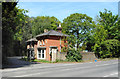
Old Lodge to Milton Park
I'm guessing Milton Park was once a country house, but now it's a modern business premises.
The old lodge here is from those earlier days and is now looking definitely surplus to requirements, empty and full of junk.
Image: © Des Blenkinsopp
Taken: 10 May 2017
0.09 miles
2
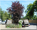
Old Car on a Trailer
Outside a vehicle yard down Clockhouse Lane.
Image: © Des Blenkinsopp
Taken: 10 May 2017
0.14 miles

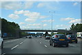
4
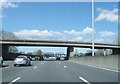
M25 northbound, New Wickham Lane Bridge
Image: © Alex McGregor
Taken: 11 Apr 2015
0.22 miles

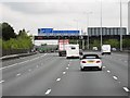

10
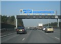
M25 passes under New Wickham Lane
The lane links Egham to Thorpe Lea.
Image: © Stuart Logan
Taken: 24 Aug 2011
0.24 miles