IMAGES TAKEN NEAR TO
Malthouse Lane, EGHAM, TW20 9BD
Introduction
This page details the photographs taken nearby to Malthouse Lane, TW20 9BD by members of the Geograph project.
The Geograph project started in 2005 with the aim of publishing, organising and preserving representative images for every square kilometre of Great Britain, Ireland and the Isle of Man.

There are currently over 7.5m images from over14,400 individuals and you can help contribute to the project by visiting https://www.geograph.org.uk
Image Map
Images are licensed for reuse under creativecommons.org/licenses/by-sa/2.0
Notes
- Clicking on the map will re-center to the selected point.
- The higher the marker number, the further away the image location is from the centre of the postcode.
Image Listing (90 Images Found)
Images are licensed for reuse under creativecommons.org/licenses/by-sa/2.0
Image
Details
Distance
1
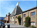
Egham Maltings
A former traditional maltings now in business use.
Image: © Des Blenkinsopp
Taken: 10 May 2017
0.01 miles
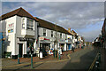
3
High St, Egham #2
This is a second view of Egham's high street, taken looking east-northeast towards the church.
Image: © Robert Lamb
Taken: 27 Feb 2010
0.05 miles
4
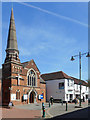
The United Church of Egham
A distinctive church on Egham's semi pedestrianised old High Street. The church name refers to the United Reformed and Methodists having joined to worship here.
Image: © Des Blenkinsopp
Taken: 10 May 2017
0.06 miles
5
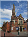
Egham United Church
A joint Methodist and United Reformed church.
Image: © Stephen Craven
Taken: 25 May 2015
0.06 miles
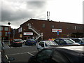
6
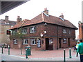
The Red Lion
Large brick tile-hung pub on the north side of Egham's pedestrianized High Street.
http://www.egham.co.uk/
Image: © Colin Smith
Taken: 20 Sep 2009
0.06 miles
8
Runnemede Road
For some reason the street name here is spelt with an E in the middle rather than the usual Y.
The famous Runnymede where the Magna Carta was signed in 1215 is at the far end of the road.
Image: © Des Blenkinsopp
Taken: 10 May 2017
0.06 miles
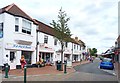
9
High Street, Egham
This is the north side looking east.
Image: © David Kemp
Taken: 14 Mar 2022
0.06 miles
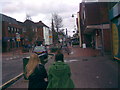
10
Egham High Street
The High Street is partially pedestrianised.
It has many small shops and a medium-sized supermarket.
Image: © mike smith
Taken: 4 Aug 2013
0.07 miles