IMAGES TAKEN NEAR TO
Coldharbour Lane, EGHAM, TW20 8TD
Introduction
This page details the photographs taken nearby to Coldharbour Lane, TW20 8TD by members of the Geograph project.
The Geograph project started in 2005 with the aim of publishing, organising and preserving representative images for every square kilometre of Great Britain, Ireland and the Isle of Man.

There are currently over 7.5m images from over14,400 individuals and you can help contribute to the project by visiting https://www.geograph.org.uk
Image Map
Images are licensed for reuse under creativecommons.org/licenses/by-sa/2.0
Notes
- Clicking on the map will re-center to the selected point.
- The higher the marker number, the further away the image location is from the centre of the postcode.
Image Listing (8 Images Found)
Images are licensed for reuse under creativecommons.org/licenses/by-sa/2.0
Image
Details
Distance
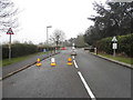
1
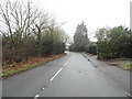
Norlands Lane at the junction of Coldharbour Lane
It's the same road but changes its name after the roundabout
Image: © David Howard
Taken: 13 Dec 2015
0.03 miles
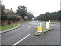
2
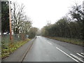
This is not the entrance to Thorpe Park
This is actually the service gate for workers and the notice on the cone says what it does in the title. It was closed anyway so the actual entrance wasn't available either.
Image: © David Howard
Taken: 13 Dec 2015
0.04 miles
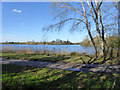
3
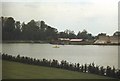
Thorpe Park Lake in early days
The old Gravel Pits now transformed into a Theme Park
Image: © John Firth
Taken: Unknown
0.14 miles
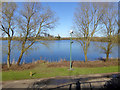
6
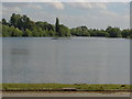
Manor Lake
A view across Manor Lake from Monks Walk. This former gravel pit is now owned by Thorpe Park.
Image: © Alan Hunt
Taken: 14 Jun 2012
0.20 miles