IMAGES TAKEN NEAR TO
Ten Acre Lane, EGHAM, TW20 8SJ
Introduction
This page details the photographs taken nearby to Ten Acre Lane, TW20 8SJ by members of the Geograph project.
The Geograph project started in 2005 with the aim of publishing, organising and preserving representative images for every square kilometre of Great Britain, Ireland and the Isle of Man.

There are currently over 7.5m images from over14,400 individuals and you can help contribute to the project by visiting https://www.geograph.org.uk
Image Map
Images are licensed for reuse under creativecommons.org/licenses/by-sa/2.0
Notes
- Clicking on the map will re-center to the selected point.
- The higher the marker number, the further away the image location is from the centre of the postcode.
Image Listing (21 Images Found)
Images are licensed for reuse under creativecommons.org/licenses/by-sa/2.0
Image
Details
Distance
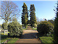
1
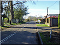
Ten Acre Lane, Thorpe
Looking towards the junction with Village Road.
Image: © Robin Webster
Taken: 16 Mar 2020
0.04 miles
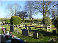
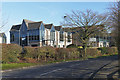
2
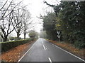
Ten Acre Lane, Thorpe
The church and graveyard are on the left.
Image: © David Howard
Taken: 13 Dec 2015
0.04 miles
7
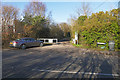
Green Lane, Thorpe
An Access road off Ten Acre Lane near the Thorpe Industrial Estate.
Image: © Alan Hunt
Taken: 14 Mar 2016
0.09 miles
8
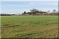
Farmland near Thorpe
One of the fields south of Ten Acre Lane.
Image: © Alan Hunt
Taken: 14 Mar 2016
0.11 miles
9
Ten Acre Lane, Thorpe
Looking east along ten Acre Lane with office units in the Thorpe Industrial Estate on the left.
Image: © Alan Hunt
Taken: 14 Mar 2016
0.16 miles
10

Thorpe Industrial Estate
An industrial unit in this small industrial park between Thorpe and Egham.
Image: © Alan Hunt
Taken: 14 Mar 2016
0.19 miles