IMAGES TAKEN NEAR TO
Harcourt Close, EGHAM, TW20 8BJ
Introduction
This page details the photographs taken nearby to Harcourt Close, TW20 8BJ by members of the Geograph project.
The Geograph project started in 2005 with the aim of publishing, organising and preserving representative images for every square kilometre of Great Britain, Ireland and the Isle of Man.

There are currently over 7.5m images from over14,400 individuals and you can help contribute to the project by visiting https://www.geograph.org.uk
Image Map
Images are licensed for reuse under creativecommons.org/licenses/by-sa/2.0
Notes
- Clicking on the map will re-center to the selected point.
- The higher the marker number, the further away the image location is from the centre of the postcode.
Image Listing (6 Images Found)
Images are licensed for reuse under creativecommons.org/licenses/by-sa/2.0
Image
Details
Distance
2
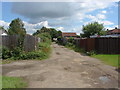
Devil's Lane, Egham Hythe
A view along Devil's Lane, an unmade access road that runs from Thorpe Lea Road to Huntingfield Way.
Image: © Alan Hunt
Taken: 5 Jul 2012
0.18 miles
3
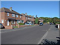
Ayebridges Avenue, Egham Hythe
The view along Ayebridges Avenue, a residential street in Egham Hythe.
Image: © Alan Hunt
Taken: 19 Sep 2012
0.20 miles
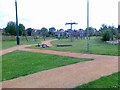
5

Recreation Area, Thorpe Lea
The small green off Ambleside Way.
Image: © Alan Hunt
Taken: 19 Sep 2012
0.25 miles
6
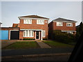
Thorpe Lea - Vicarage Court
Modern detached houses.
Image: © James Emmans
Taken: 3 Jan 2017
0.25 miles