IMAGES TAKEN NEAR TO
Pooley Green Road, EGHAM, TW20 8AF
Introduction
This page details the photographs taken nearby to Pooley Green Road, TW20 8AF by members of the Geograph project.
The Geograph project started in 2005 with the aim of publishing, organising and preserving representative images for every square kilometre of Great Britain, Ireland and the Isle of Man.

There are currently over 7.5m images from over14,400 individuals and you can help contribute to the project by visiting https://www.geograph.org.uk
Image Map
Images are licensed for reuse under creativecommons.org/licenses/by-sa/2.0
Notes
- Clicking on the map will re-center to the selected point.
- The higher the marker number, the further away the image location is from the centre of the postcode.
Image Listing (19 Images Found)
Images are licensed for reuse under creativecommons.org/licenses/by-sa/2.0
Image
Details
Distance
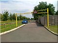
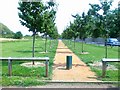
2
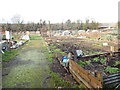
Pooley Green - Allotments
Wikipedia : https://en.wikipedia.org/wiki/Allotment_(gardening)
Image: © James Emmans
Taken: 3 Jan 2017
0.14 miles
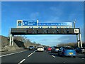
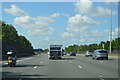
4

Borough of Runnymede : M25 Motorway
Heading along the M25 between Junction 13 (Runnymede) and Junction 12 (Thorpe Interchange).
Image: © Lewis Clarke
Taken: 25 Mar 2018
0.20 miles
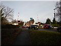
7
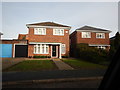
Thorpe Lea - Vicarage Court
Modern detached houses.
Image: © James Emmans
Taken: 3 Jan 2017
0.21 miles