IMAGES TAKEN NEAR TO
Kings Lane, EGHAM, TW20 0UE
Introduction
This page details the photographs taken nearby to Kings Lane, TW20 0UE by members of the Geograph project.
The Geograph project started in 2005 with the aim of publishing, organising and preserving representative images for every square kilometre of Great Britain, Ireland and the Isle of Man.

There are currently over 7.5m images from over14,400 individuals and you can help contribute to the project by visiting https://www.geograph.org.uk
Image Map
Images are licensed for reuse under creativecommons.org/licenses/by-sa/2.0
Notes
- Clicking on the map will re-center to the selected point.
- The higher the marker number, the further away the image location is from the centre of the postcode.
Image Listing (53 Images Found)
Images are licensed for reuse under creativecommons.org/licenses/by-sa/2.0
Image
Details
Distance
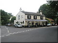
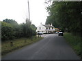
1

The Sun public house
The Sun public house on the junction of the lane from Englefield Green
Image: © Shaun Ferguson
Taken: 14 Sep 2007
0.01 miles
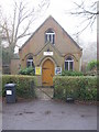
4
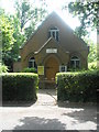
Bishopsgate Evangelical Church in Kings Lane
Image: © Basher Eyre
Taken: 14 Jun 2009
0.02 miles

10
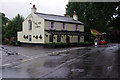
Th' Sun, Wick Lane
Spot the differences with Image (2007).
Image: © Ian Taylor
Taken: 13 Jul 2015
0.03 miles