IMAGES TAKEN NEAR TO
Hazel Close, EGHAM, TW20 0TN
Introduction
This page details the photographs taken nearby to Hazel Close, TW20 0TN by members of the Geograph project.
The Geograph project started in 2005 with the aim of publishing, organising and preserving representative images for every square kilometre of Great Britain, Ireland and the Isle of Man.

There are currently over 7.5m images from over14,400 individuals and you can help contribute to the project by visiting https://www.geograph.org.uk
Image Map
Images are licensed for reuse under creativecommons.org/licenses/by-sa/2.0
Notes
- Clicking on the map will re-center to the selected point.
- The higher the marker number, the further away the image location is from the centre of the postcode.
Image Listing (113 Images Found)
Images are licensed for reuse under creativecommons.org/licenses/by-sa/2.0
Image
Details
Distance
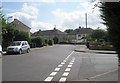
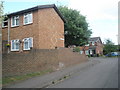
1
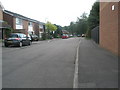
Sunday morning on the Forest Estate at Englefield Green
Image: © Basher Eyre
Taken: 14 Jun 2009
0.01 miles
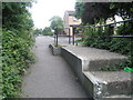
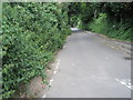
3
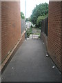
Cut through from Magna Road to Blays Lane
Image: © Basher Eyre
Taken: 14 Jun 2009
0.03 miles
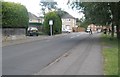
4
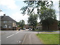
Looking from Ashwood Road towards the crossroads with Elmbank Avenue
Image: © Basher Eyre
Taken: 14 Jun 2009
0.03 miles
5
Junction of Larchwood Drive and Elmbank Avenue
Image: © Basher Eyre
Taken: 14 Jun 2009
0.04 miles
6
Ashwood Road approaching Elmbank Avenue
Image: © Basher Eyre
Taken: 14 Jun 2009
0.04 miles
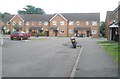
8
Looking across Elmbank Avenue towards Hazel Close
Image: © Basher Eyre
Taken: 14 Jun 2009
0.05 miles
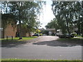
10
Approaching the junction of Swallowfield and Heronfield
Image: © Basher Eyre
Taken: 14 Jun 2009
0.06 miles