IMAGES TAKEN NEAR TO
Firbank Place, EGHAM, TW20 0ST
Introduction
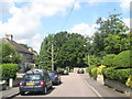
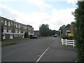
This page details the photographs taken nearby to Firbank Place, TW20 0ST by members of the Geograph project.
The Geograph project started in 2005 with the aim of publishing, organising and preserving representative images for every square kilometre of Great Britain, Ireland and the Isle of Man.

There are currently over 7.5m images from over14,400 individuals and you can help contribute to the project by visiting https://www.geograph.org.uk
Image Map
Images are licensed for reuse under creativecommons.org/licenses/by-sa/2.0
Notes
- Clicking on the map will re-center to the selected point.
- The higher the marker number, the further away the image location is from the centre of the postcode.
Image Listing (107 Images Found)
Images are licensed for reuse under creativecommons.org/licenses/by-sa/2.0
Image
Details
Distance
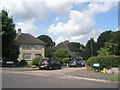
1
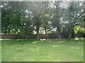
Entrance from Kings Road Open Space into Firbank Place
Image: © Basher Eyre
Taken: 14 Jun 2009
0.01 miles
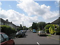
2
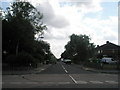
Looking from Kingsley Avenue into Magna Road
Image: © Basher Eyre
Taken: 14 Jun 2009
0.02 miles
3
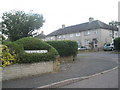
Junction of Beechtree Avenue and Firbank Place
Image: © Basher Eyre
Taken: 14 Jun 2009
0.02 miles
4
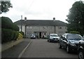
Looking from Firbank Close towards Beechtree Avenue
Image: © Basher Eyre
Taken: 14 Jun 2009
0.02 miles
5
Junction of Firbank Place and Beechtree Avenue
Image: © Basher Eyre
Taken: 14 Jun 2009
0.02 miles
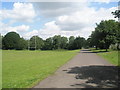
6
Looking southwards down Beechwood Avenue
Image: © Basher Eyre
Taken: 14 Jun 2009
0.03 miles
10
Looking from Firbank Close towards the bus stop in Beechtree Avenue
Image: © Basher Eyre
Taken: 14 Jun 2009
0.03 miles