IMAGES TAKEN NEAR TO
Harvest Road, EGHAM, TW20 0SG
Introduction
This page details the photographs taken nearby to Harvest Road, TW20 0SG by members of the Geograph project.
The Geograph project started in 2005 with the aim of publishing, organising and preserving representative images for every square kilometre of Great Britain, Ireland and the Isle of Man.

There are currently over 7.5m images from over14,400 individuals and you can help contribute to the project by visiting https://www.geograph.org.uk
Image Map
Images are licensed for reuse under creativecommons.org/licenses/by-sa/2.0
Notes
- Clicking on the map will re-center to the selected point.
- The higher the marker number, the further away the image location is from the centre of the postcode.
Image Listing (148 Images Found)
Images are licensed for reuse under creativecommons.org/licenses/by-sa/2.0
Image
Details
Distance
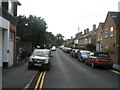
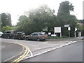
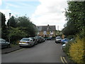
1
Junction of Victoria Street and Harvest Road
Image: © Basher Eyre
Taken: 14 Jun 2009
0.01 miles
2

Entrance to car park for Arista Court in Harvest Road
Image: © Basher Eyre
Taken: 14 Jun 2009
0.01 miles
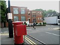
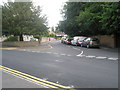
4
Junction of Harvest Road and Victoria Street
Image: © Basher Eyre
Taken: 14 Jun 2009
0.02 miles
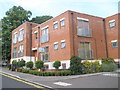
5
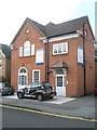
Newly converted flats at the former Englefield Green Constitutional Club
Image: © Basher Eyre
Taken: 14 Jun 2009
0.03 miles
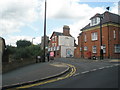
6
Junction of Harvest Road and St Cuthbert's Close
Image: © Basher Eyre
Taken: 14 Jun 2009
0.03 miles
7
Looking across from Harvest Road to Parsonage Road
Image: © Basher Eyre
Taken: 14 Jun 2009
0.04 miles
8
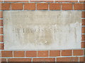
Foundation stone at Englefield Green Social Club (2)
Image: © Basher Eyre
Taken: 14 Jun 2009
0.04 miles
9
Looking along St Cuthbert's Close towards Harvest Road
Image: © Basher Eyre
Taken: 14 Jun 2009
0.04 miles