IMAGES TAKEN NEAR TO
Bagshot Road, EGHAM, TW20 0RS
Introduction
This page details the photographs taken nearby to Bagshot Road, TW20 0RS by members of the Geograph project.
The Geograph project started in 2005 with the aim of publishing, organising and preserving representative images for every square kilometre of Great Britain, Ireland and the Isle of Man.

There are currently over 7.5m images from over14,400 individuals and you can help contribute to the project by visiting https://www.geograph.org.uk
Image Map
Images are licensed for reuse under creativecommons.org/licenses/by-sa/2.0
Notes
- Clicking on the map will re-center to the selected point.
- The higher the marker number, the further away the image location is from the centre of the postcode.
Image Listing (182 Images Found)
Images are licensed for reuse under creativecommons.org/licenses/by-sa/2.0
Image
Details
Distance
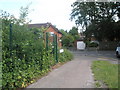
3
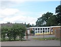
St Jude's C of E Primary School
At the junction of Corby Drive and Bagshot Road.
Image: © Basher Eyre
Taken: 14 Jun 2009
0.03 miles
4
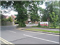
Approaching the junction of Corby Close and Bagshot Drive
Image: © Basher Eyre
Taken: 14 Jun 2009
0.03 miles
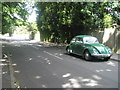
6
Looking across Bagshot Road towards Fircroft Road
Image: © Basher Eyre
Taken: 14 Jun 2009
0.04 miles
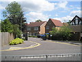
8
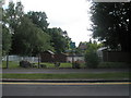
St Cuthbert's RC Primary School
At the junction of Corby Drive and Bagshot Road.
Image: © Basher Eyre
Taken: 14 Jun 2009
0.05 miles