IMAGES TAKEN NEAR TO
Kingsley Avenue, EGHAM, TW20 0PT
Introduction
This page details the photographs taken nearby to Kingsley Avenue, TW20 0PT by members of the Geograph project.
The Geograph project started in 2005 with the aim of publishing, organising and preserving representative images for every square kilometre of Great Britain, Ireland and the Isle of Man.

There are currently over 7.5m images from over14,400 individuals and you can help contribute to the project by visiting https://www.geograph.org.uk
Image Map
Images are licensed for reuse under creativecommons.org/licenses/by-sa/2.0
Notes
- Clicking on the map will re-center to the selected point.
- The higher the marker number, the further away the image location is from the centre of the postcode.
Image Listing (132 Images Found)
Images are licensed for reuse under creativecommons.org/licenses/by-sa/2.0
Image
Details
Distance
1
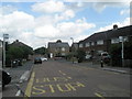
Looking from Kingsley Avenue back to Bond Street
Image: © Basher Eyre
Taken: 14 Jun 2009
0.02 miles
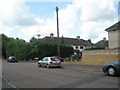
2

Junction of Bond Street and Kingsley Avenue
Image: © Basher Eyre
Taken: 14 Jun 2009
0.02 miles
3
Looking from Kings Lane towards Northcroft Road
Image: © Basher Eyre
Taken: 14 Jun 2009
0.02 miles
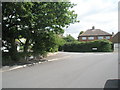
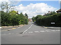
4

Looking southwards down Kingsley Avenue
Image: © Basher Eyre
Taken: 14 Jun 2009
0.03 miles
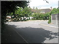
7
Junction of Kingsley Avenue and Almond Close
Image: © Basher Eyre
Taken: 14 Jun 2009
0.05 miles
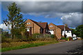
8
Shadows in Bond Street approaching Northcroft Road
Image: © Basher Eyre
Taken: 14 Jun 2009
0.06 miles
9
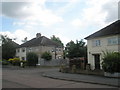
Junction of Kingsley Avenue and Cypress Walk
Image: © Basher Eyre
Taken: 14 Jun 2009
0.06 miles
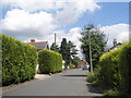
10
Looking north from Northcroft Road
Taken from the boundary of Kings Lane and Bond Street.
Image: © Basher Eyre
Taken: 14 Jun 2009
0.07 miles