IMAGES TAKEN NEAR TO
Alderside Walk, EGHAM, TW20 0LY
Introduction
This page details the photographs taken nearby to Alderside Walk, TW20 0LY by members of the Geograph project.
The Geograph project started in 2005 with the aim of publishing, organising and preserving representative images for every square kilometre of Great Britain, Ireland and the Isle of Man.

There are currently over 7.5m images from over14,400 individuals and you can help contribute to the project by visiting https://www.geograph.org.uk
Image Map
Images are licensed for reuse under creativecommons.org/licenses/by-sa/2.0
Notes
- Clicking on the map will re-center to the selected point.
- The higher the marker number, the further away the image location is from the centre of the postcode.
Image Listing (36 Images Found)
Images are licensed for reuse under creativecommons.org/licenses/by-sa/2.0
Image
Details
Distance
1
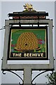
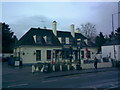
The Beehive
Pub sign: Fuller's pub on Middle Hill
Image: © John Myers
Taken: 2 Jun 2012
0.06 miles
2
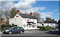
The Beehive
A Fullers Brewery pub on Middle Hill.
Image: © Des Blenkinsopp
Taken: 21 Mar 2017
0.06 miles
4
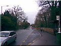
View looking down Egham Hill towards the Monkey's Forehead
This is a view looking down Egham Hill towards the Monkey's Forehead, the white frontage of which can just be seen in the distance. View taken looking north-northeast.
Image: © Robert Lamb
Taken: 27 Feb 2010
0.13 miles
5
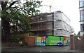
New Student Accommodation at Royal Holloway University
Image: © Anthony Parkes
Taken: 2 Jun 2015
0.14 miles
6
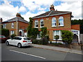
Egham - Late Victorian Houses in Middle Hill
Image: © James Emmans
Taken: 7 Jun 2017
0.17 miles
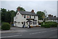
7
The Monkey's Forehead, Egham Hill
This rather weirdly named pub is located on Egham Hill just down the road from Royal Holloway University. View taken looking north-northeast.
Image: © Robert Lamb
Taken: 27 Feb 2010
0.17 miles
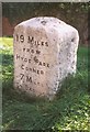
8
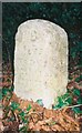
Old Milestone by Tite Hill, Egham
Forest square milestone by the UC road, in parish of Egham (Runnymede District), top of Tite Hill, just South of Seymour Court, on wide verge under trees between road and a metal fence with holly bushes.
Inscription reads:-
19
MILES
FROM
HYDE PARK
CORNER
Carved benchmark recorded.
Grade II listed.
List Entry Number: 1028922 https://historicengland.org.uk/listing/the-list/list-entry/1028922
Surveyed
Milestone Society National ID: SY_lrf19
Image: © Milestone Society
Taken: Unknown
0.17 miles
9
Old Milestone (north face) by the A30, Egham Hill, Egham
Reused Hounslow limestone square by the A30, in parish of Egham (Runnymede District), East of Royal Holloway College, just West of footbridge, on wide well cut verge between path and a wall.
Inscription reads:- : 19 miles / FROM / HYDE PARK / CORNER / 7 MILES / TO BAGSHOT : : XIX / Miles (to) / Hyde Park / Corner / 1743 :
Carved bench mark and rivet on top.
Surveyed
Milestone Society National ID: SY_le19
Image: © Milestone Society
Taken: 9 Apr 2009
0.19 miles
10
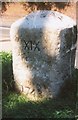
Old Milestone (south face) by the A30, Egham Hill, Egham
Re-used Hounslow limestone square by the A30, in parish of Egham (Runnymede District), East of Royal Holloway College, just West of footbridge, on wide well cut verge between path and a wall.
Inscription reads:- : 19 miles / FROM / HYDE PARK / CORNER / 7 MILES / TO BAGSHOT : : XIX / Miles (to) / Hyde Park / Corner / 1743 :
Carved bench mark and rivet on top.
Surveyed
Milestone Society National ID: SY_le19
Image: © Milestone Society
Taken: 9 Apr 2009
0.19 miles