IMAGES TAKEN NEAR TO
Hollycombe, EGHAM, TW20 0LQ
Introduction
This page details the photographs taken nearby to Hollycombe, TW20 0LQ by members of the Geograph project.
The Geograph project started in 2005 with the aim of publishing, organising and preserving representative images for every square kilometre of Great Britain, Ireland and the Isle of Man.

There are currently over 7.5m images from over14,400 individuals and you can help contribute to the project by visiting https://www.geograph.org.uk
Image Map
Images are licensed for reuse under creativecommons.org/licenses/by-sa/2.0
Notes
- Clicking on the map will re-center to the selected point.
- The higher the marker number, the further away the image location is from the centre of the postcode.
Image Listing (36 Images Found)
Images are licensed for reuse under creativecommons.org/licenses/by-sa/2.0
Image
Details
Distance
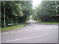
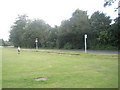
1

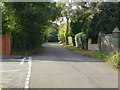
Hollycombe, Englefield Green
The short residential road next to the tennis courts on the Cooper's Hill area of Englefield Green.
Image: © Alan Hunt
Taken: 27 Sep 2012
0.06 miles
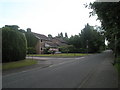
2
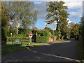
Cooper's Hill Lane
Cooper's Hill Lane with the junction of Hollycombe on the left.
Image: © Alan Hunt
Taken: 27 Sep 2012
0.10 miles
3
Cooper's Hill Lane
The view along Cooper's Hill Lane with the former Runnymede Campus of Brunel University on the left.
Image: © Alan Hunt
Taken: 27 Sep 2012
0.10 miles
4
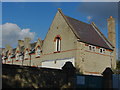
Runnymede Campus, Brunel University
One of the buildings of the now disused Runnymede Campus of Brunel University.
Image: © Alan Hunt
Taken: 27 Sep 2012
0.10 miles
5
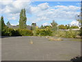
Runnymede Campus, Brunel University
A car park on the now disused Runnymede Campus of Brunel University. The campus was sold a few years ago and is the subject of a planning application to turn it into a care home and private housing.
Image: © Alan Hunt
Taken: 27 Sep 2012
0.12 miles
6
Junction of the A328 with Barley Mow Road
Image: © Basher Eyre
Taken: 14 Jun 2009
0.14 miles
7

Cattle Trough, Englefield Green
Old cattle / horse trough and drinking fountain at junction of St Judes Road, Bishopsgate and Coopers Hill Lane in Englefield Green. The inscription reads "Metropolitan Drinking Fountain & Cattle Trough Association".
Image: © Sean Davis
Taken: 30 Mar 2015
0.14 miles
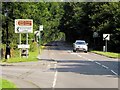
9
Bend ahead on the A328 at Englefield Green
Image: © Basher Eyre
Taken: 14 Jun 2009
0.14 miles
10
Approaching the junction of Barley Mow Road and Bulkeley Close
Image: © Basher Eyre
Taken: 14 Jun 2009
0.14 miles