IMAGES TAKEN NEAR TO
Beauforts, EGHAM, TW20 0DW
Introduction
This page details the photographs taken nearby to Beauforts, TW20 0DW by members of the Geograph project.
The Geograph project started in 2005 with the aim of publishing, organising and preserving representative images for every square kilometre of Great Britain, Ireland and the Isle of Man.

There are currently over 7.5m images from over14,400 individuals and you can help contribute to the project by visiting https://www.geograph.org.uk
Image Map
Images are licensed for reuse under creativecommons.org/licenses/by-sa/2.0
Notes
- Clicking on the map will re-center to the selected point.
- The higher the marker number, the further away the image location is from the centre of the postcode.
Image Listing (120 Images Found)
Images are licensed for reuse under creativecommons.org/licenses/by-sa/2.0
Image
Details
Distance
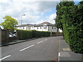
3
Looking from Englefield Green over the A328 towards Barley Mow Road
Image: © Basher Eyre
Taken: 14 Jun 2009
0.03 miles
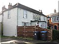
5
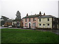
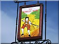
Houses on Englefield Green
In the middle of the row of houses is The Barley Mow pub.
Image: © don cload
Taken: 22 Feb 2011
0.04 miles
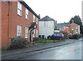
7
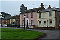
Houses and public house facing onto the green
This is a mid-morning view but the quaint streetlight is still on in the January overcast.
Image: © David Martin
Taken: 10 Jan 2013
0.05 miles
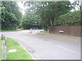
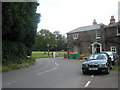
8
Junction of St Jude's Road and Beauforts
Image: © Basher Eyre
Taken: 14 Jun 2009
0.05 miles
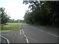
9
Northcroft Lane approaching Englefield Green
Image: © Basher Eyre
Taken: 14 Jun 2009
0.05 miles
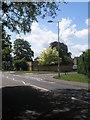
10
Junction of Englefield Green and the A328
Image: © Basher Eyre
Taken: 14 Jun 2009
0.05 miles