IMAGES TAKEN NEAR TO
St. Judes Road, EGHAM, TW20 0DB
Introduction
This page details the photographs taken nearby to St. Judes Road, TW20 0DB by members of the Geograph project.
The Geograph project started in 2005 with the aim of publishing, organising and preserving representative images for every square kilometre of Great Britain, Ireland and the Isle of Man.

There are currently over 7.5m images from over14,400 individuals and you can help contribute to the project by visiting https://www.geograph.org.uk
Image Map
Images are licensed for reuse under creativecommons.org/licenses/by-sa/2.0
Notes
- Clicking on the map will re-center to the selected point.
- The higher the marker number, the further away the image location is from the centre of the postcode.
Image Listing (233 Images Found)
Images are licensed for reuse under creativecommons.org/licenses/by-sa/2.0
Image
Details
Distance
6
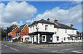
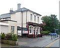
The Holly Tree
Corner of St Jude's Road and Victoria Street.
Image: © Des Blenkinsopp
Taken: 21 Mar 2017
0.02 miles
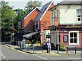
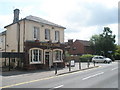
8
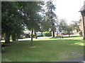
Green between St Jude's Road and Bond Street
Image: © Basher Eyre
Taken: 14 Jun 2009
0.02 miles
9
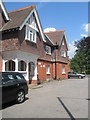
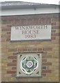
Not quite what I would call a cottage
St Jude's Cottage in St Jude's Road- now flats.
Image: © Basher Eyre
Taken: 14 Jun 2009
0.02 miles