IMAGES TAKEN NEAR TO
Highfield Road, EGHAM, TW20 0BW
Introduction
This page details the photographs taken nearby to Highfield Road, TW20 0BW by members of the Geograph project.
The Geograph project started in 2005 with the aim of publishing, organising and preserving representative images for every square kilometre of Great Britain, Ireland and the Isle of Man.

There are currently over 7.5m images from over14,400 individuals and you can help contribute to the project by visiting https://www.geograph.org.uk
Image Map
Images are licensed for reuse under creativecommons.org/licenses/by-sa/2.0
Notes
- Clicking on the map will re-center to the selected point.
- The higher the marker number, the further away the image location is from the centre of the postcode.
Image Listing (178 Images Found)
Images are licensed for reuse under creativecommons.org/licenses/by-sa/2.0
Image
Details
Distance
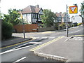
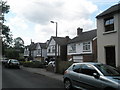
1
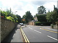
One way system ahead in Harvest Road
The part running round to the right will soon become South Road.
Image: © Basher Eyre
Taken: 14 Jun 2009
0.01 miles
2
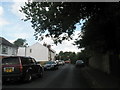
Looking along Harvest Road towards The Happy Man
Image: © Basher Eyre
Taken: 14 Jun 2009
0.03 miles
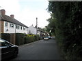
4
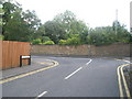
South Road merges at the bend into Harvest Road
Image: © Basher Eyre
Taken: 14 Jun 2009
0.04 miles
5
End of the one way system in South Road
Image: © Basher Eyre
Taken: 14 Jun 2009
0.04 miles
6
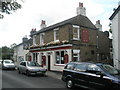
Not Victor Meldrew's local, I presume
The Happy Man in Harvest Road.
Image: © Basher Eyre
Taken: 14 Jun 2009
0.07 miles
7
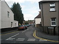
Looking from South Road into Albert Road
Image: © Basher Eyre
Taken: 14 Jun 2009
0.07 miles
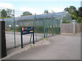
10
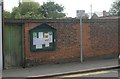
Noticeboard in Victoria Street
EGVRA is the Englefield Green Village Residents Association http://www.englefieldgreen.org.uk/locinfo/egvra.html
Image: © Basher Eyre
Taken: 14 Jun 2009
0.08 miles