IMAGES TAKEN NEAR TO
Egham Hill, EGHAM, TW20 0BL
Introduction
This page details the photographs taken nearby to Egham Hill, TW20 0BL by members of the Geograph project.
The Geograph project started in 2005 with the aim of publishing, organising and preserving representative images for every square kilometre of Great Britain, Ireland and the Isle of Man.

There are currently over 7.5m images from over14,400 individuals and you can help contribute to the project by visiting https://www.geograph.org.uk
Image Map
Images are licensed for reuse under creativecommons.org/licenses/by-sa/2.0
Notes
- Clicking on the map will re-center to the selected point.
- The higher the marker number, the further away the image location is from the centre of the postcode.
Image Listing (116 Images Found)
Images are licensed for reuse under creativecommons.org/licenses/by-sa/2.0
Image
Details
Distance
1
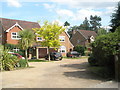
Houses at the far end of St Cuthbert's Close
Image: © Basher Eyre
Taken: 14 Jun 2009
0.05 miles
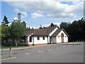
2
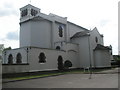
Presbytery behind The Assumption of our Lady, Englefield Green
Image: © Basher Eyre
Taken: 14 Jun 2009
0.06 miles
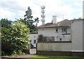
3
The Jurgens Centre, St Cuthbert's Close
Image: © Basher Eyre
Taken: 14 Jun 2009
0.08 miles
4
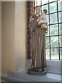
Statue within The Assumption of Our Lady, Englefield Green (2)
Image: © Basher Eyre
Taken: 14 Jun 2009
0.09 miles
5
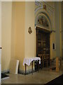
Door within The Assumption of our Lady, Englefield Green
Image: © Basher Eyre
Taken: 14 Jun 2009
0.09 miles
6
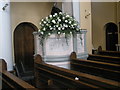
The pulpit at The Assumption of Our Lady, Englefield Green
Image: © Basher Eyre
Taken: 14 Jun 2009
0.09 miles
7
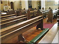
Pews within The Assumption of Our Lady, Englefield Green
Image: © Basher Eyre
Taken: 14 Jun 2009
0.09 miles
8
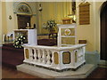
Lectern within The Assumption of Our Lady, Englefield Green
Image: © Basher Eyre
Taken: 14 Jun 2009
0.09 miles
9
Rear of The Assumption of our Lady, Englefield Green
Image: © Basher Eyre
Taken: 14 Jun 2009
0.09 miles
10
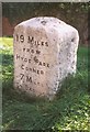
Old Milestone (north face) by the A30, Egham Hill, Egham
Reused Hounslow limestone square by the A30, in parish of Egham (Runnymede District), East of Royal Holloway College, just West of footbridge, on wide well cut verge between path and a wall.
Inscription reads:- : 19 miles / FROM / HYDE PARK / CORNER / 7 MILES / TO BAGSHOT : : XIX / Miles (to) / Hyde Park / Corner / 1743 :
Carved bench mark and rivet on top.
Surveyed
Milestone Society National ID: SY_le19
Image: © Milestone Society
Taken: 9 Apr 2009
0.09 miles