IMAGES TAKEN NEAR TO
Queenswood Crescent, EGHAM, TW20 0AT
Introduction
This page details the photographs taken nearby to Queenswood Crescent, TW20 0AT by members of the Geograph project.
The Geograph project started in 2005 with the aim of publishing, organising and preserving representative images for every square kilometre of Great Britain, Ireland and the Isle of Man.

There are currently over 7.5m images from over14,400 individuals and you can help contribute to the project by visiting https://www.geograph.org.uk
Image Map
Images are licensed for reuse under creativecommons.org/licenses/by-sa/2.0
Notes
- Clicking on the map will re-center to the selected point.
- The higher the marker number, the further away the image location is from the centre of the postcode.
Image Listing (65 Images Found)
Images are licensed for reuse under creativecommons.org/licenses/by-sa/2.0
Image
Details
Distance
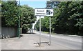
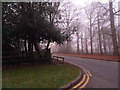
4
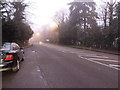
The A30 in Englefield Green
Compare with a slightly earlier view here http://www.geograph.org.uk/photo/4279646
Image: © David Howard
Taken: 13 Dec 2015
0.08 miles
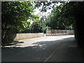
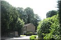
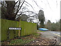
6
Entrance to business park on Wick Road, Englefield Green
Image: © David Howard
Taken: 13 Dec 2015
0.10 miles
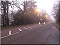
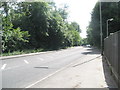
8
Wick Road at the junction of the A30, Englefield Green
Image: © David Howard
Taken: 3 Feb 2013
0.11 miles