IMAGES TAKEN NEAR TO
Jubilee Close, STAINES-UPON-THAMES, TW19 7PX
Introduction
This page details the photographs taken nearby to Jubilee Close, TW19 7PX by members of the Geograph project.
The Geograph project started in 2005 with the aim of publishing, organising and preserving representative images for every square kilometre of Great Britain, Ireland and the Isle of Man.

There are currently over 7.5m images from over14,400 individuals and you can help contribute to the project by visiting https://www.geograph.org.uk
Image Map
Images are licensed for reuse under creativecommons.org/licenses/by-sa/2.0
Notes
- Clicking on the map will re-center to the selected point.
- The higher the marker number, the further away the image location is from the centre of the postcode.
Image Listing (50 Images Found)
Images are licensed for reuse under creativecommons.org/licenses/by-sa/2.0
Image
Details
Distance
1
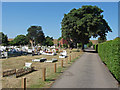
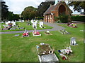
Stanwell cemetery
The cemetery between Town Lane and the embankment of Staines reservoir.
Image: © Alan Hunt
Taken: 1 Aug 2013
0.05 miles
2
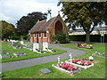
Stanwell Burial Ground and its disused chapel
Stanwell Burial Ground opened between 1895 and 1910 off Town Lane. Beyond is the embankment of Staines Reservoir, completed in 1902.
Image: © Marathon
Taken: 10 Sep 2014
0.07 miles
3
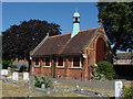
Stanwell cemetery chapel
The chapel of remembrance built in 1903. The windows are currently boarded up.
Image: © Alan Hunt
Taken: 1 Aug 2013
0.07 miles
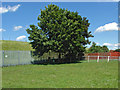
4
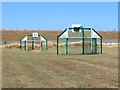
Stanwell recreation ground
A basketball court in the recreation ground off Town Lane with the embankment of the Staines reservoir in the background.
Image: © Alan Hunt
Taken: 1 Aug 2013
0.07 miles
5
Stanwell Burial Ground
Stanwell Burial Ground opened between 1895 and 1910 off Town Lane. Beyond can be seen the embankment of Staines Reservoir, completed in 1902. The chapel seems to be derelict and disused.
Image: © Marathon
Taken: 10 Sep 2014
0.07 miles
6
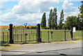
Fine Old Park Gates
Sadly not in use any more, unless it's still a vehicle entrance.
Stanwell Recreation Ground.
Image: © Des Blenkinsopp
Taken: 6 Jun 2019
0.07 miles
7
Green off Lauser road
A small green off Lauser Road with the embankment of the Staines reservoir in the background.
Image: © Alan Hunt
Taken: 8 Jun 2014
0.08 miles
8
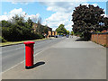
A Generous Cycleway along Town Lane
Now that's what I call a cycle path. You could hold the Tour de Staines along here.
Image: © Des Blenkinsopp
Taken: 6 Jun 2019
0.09 miles
9
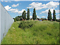
Footpath, Staines reservoir
The footpath that tracks around the perimeter fence from the cemetery to Park Road. The Town Lane recreation ground is on the right.
Image: © Alan Hunt
Taken: 8 Jun 2014
0.10 miles
10
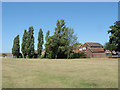
Stanwell recreation ground
The northern edge of the recreation ground off Town Lane.
Image: © Alan Hunt
Taken: 1 Aug 2013
0.10 miles