IMAGES TAKEN NEAR TO
Stanhope Way, STAINES-UPON-THAMES, TW19 7PJ
Introduction
This page details the photographs taken nearby to Stanhope Way, TW19 7PJ by members of the Geograph project.
The Geograph project started in 2005 with the aim of publishing, organising and preserving representative images for every square kilometre of Great Britain, Ireland and the Isle of Man.

There are currently over 7.5m images from over14,400 individuals and you can help contribute to the project by visiting https://www.geograph.org.uk
Image Map
Images are licensed for reuse under creativecommons.org/licenses/by-sa/2.0
Notes
- Clicking on the map will re-center to the selected point.
- The higher the marker number, the further away the image location is from the centre of the postcode.
Image Listing (106 Images Found)
Images are licensed for reuse under creativecommons.org/licenses/by-sa/2.0
Image
Details
Distance
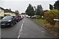
1
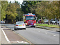
Fire engine on call, Stanwell
Heading west on Park Road.
Image: © Robin Webster
Taken: 22 Oct 2017
0.03 miles
2
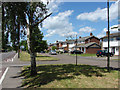
Park Road, Stanwell
Looking west along Park Road.
Image: © Alan Hunt
Taken: 8 Jun 2014
0.04 miles
5
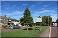
Stanwell Village sign, Park Road
Like many places around big cities, Stanwell was an old village long before being overtaken by suburbs.
Image: © Des Blenkinsopp
Taken: 21 Aug 2015
0.05 miles
6
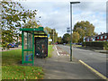
Eastbound Selwood Gardens bus stop, Stanwell
Served by route 442 towards Staines.
Image: © Robin Webster
Taken: 22 Oct 2017
0.05 miles
7
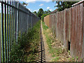
Footpath by the Staines Reservoir
The footpath that follows the perimeter fence around the northeast corner of the Staones Reservoir.
Image: © Alan Hunt
Taken: 8 Jun 2014
0.06 miles