IMAGES TAKEN NEAR TO
Lord Knyvett Close, STAINES-UPON-THAMES, TW19 7PF
Introduction
This page details the photographs taken nearby to Lord Knyvett Close, TW19 7PF by members of the Geograph project.
The Geograph project started in 2005 with the aim of publishing, organising and preserving representative images for every square kilometre of Great Britain, Ireland and the Isle of Man.

There are currently over 7.5m images from over14,400 individuals and you can help contribute to the project by visiting https://www.geograph.org.uk
Image Map
Images are licensed for reuse under creativecommons.org/licenses/by-sa/2.0
Notes
- Clicking on the map will re-center to the selected point.
- The higher the marker number, the further away the image location is from the centre of the postcode.
Image Listing (105 Images Found)
Images are licensed for reuse under creativecommons.org/licenses/by-sa/2.0
Image
Details
Distance
3
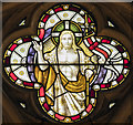
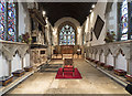
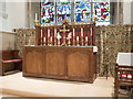
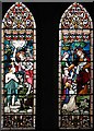
St Mary, Stanwell - Stained glass window
Image: © John Salmon
Taken: 19 Oct 2017
0.03 miles
4
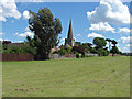
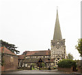
Recreation area, Stanwell
The large green off Town Lane with the church of St Mary the Virgin.
Image: © Alan Hunt
Taken: 8 Jun 2014
0.03 miles
6
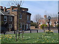
Stanwell
Showing houses overlooking the village green.
Image: © David Squire
Taken: 22 Apr 2006
0.03 miles
7
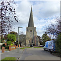
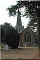
Stanwell church
St. Mary's is a grade I listed building. The spire is distinctly wonky.
Image: © Robin Webster
Taken: 22 Oct 2017
0.03 miles