IMAGES TAKEN NEAR TO
Bedfont Road, STAINES-UPON-THAMES, TW19 7LY
Introduction
This page details the photographs taken nearby to Bedfont Road, TW19 7LY by members of the Geograph project.
The Geograph project started in 2005 with the aim of publishing, organising and preserving representative images for every square kilometre of Great Britain, Ireland and the Isle of Man.

There are currently over 7.5m images from over14,400 individuals and you can help contribute to the project by visiting https://www.geograph.org.uk
Image Map
Images are licensed for reuse under creativecommons.org/licenses/by-sa/2.0
Notes
- Clicking on the map will re-center to the selected point.
- The higher the marker number, the further away the image location is from the centre of the postcode.
Image Listing (40 Images Found)
Images are licensed for reuse under creativecommons.org/licenses/by-sa/2.0
Image
Details
Distance
1
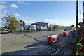
Crane Road and Scania dealers
Crane Road goes to crane and used commercial vehicle businesses, some way down behind the Scania premises.
Image: © Robin Webster
Taken: 22 Oct 2017
0.01 miles
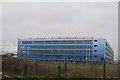
4
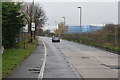
Car park near Heathrow
One of the many car parks associated with the Heathrow infrastructure. The cargo terminals are in the background.
Image: © Alan Hunt
Taken: 5 Jun 2014
0.05 miles
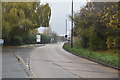
5
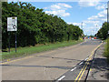
Bedfont Road
Looking east along Bedfont Road towards the roundabout that marks its end.
Image: © Alan Hunt
Taken: 5 Jun 2014
0.08 miles
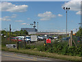
7
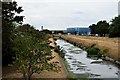
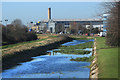
West along the Longford River towards Heathrow Cargo Terminal
View from the bridge on Beacon Road which crosses both this and the Duke of Northumberland's River to the north, just before entering the roundabout on the Southern Perimeter Road. Both watercourses divert water from the River Colne, the Longford (c. 1640) to supply water features at Hampton Court and Bushy Park, the D.O.N (c. 1530) to irrigate the Duke's estates. The two rivers run parallel to each other in concrete channels for around 6 km around the western and southern airport perimeters separated by a narrow grass "central reservation".
Image: © John Myers
Taken: 20 Jul 2018
0.08 miles
8
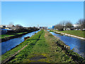
The Longford River near Heathrow
On the left is the Longford River and hidden to the right is The Duke of Northumberland's River. To the south of Heathrow Airport and its Southern Perimeter Road, the two waterways run parallel and it is possible to follow a track between them. Here they are known as the Twin Rivers.
Charles I ordered the construction of the totally artificial watercourse known as the Longford River to carry water from the River Colne to the water features in Bushy Park and then on to the Long Water in Home Park at Hampton Court. The Longford River opened in 1638.
This western section of the Duke of Northumberland's River was constructed during the reign of King Henry VIIIth. It takes water from the River Colne and was designed to supplement the flow to existing mills.
The Southern Perimeter Road is beyond the Duke of Northumberland's River to the right and Stanwell Road is beyond the trees to the left. The lamp posts of both roads can be seen.
Image: © Marathon
Taken: 10 Sep 2014
0.10 miles
9
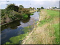
Duke of Northumberland's River south of the airport
The Duke's River, an artificial watercourse from Tudor times, was further diverted in the 20th century to skirt around the edge of Heathrow Airport.
Image: © Des Blenkinsopp
Taken: 28 Jan 2019
0.11 miles
10
Side by Side Rivers
Two rivers, the Longford and the Duke of Northumberland's, once followed separate courses over the area which is now Heathrow Airport. Both rivers were diverted to flow around the edge of the airport, still in individual channels at slightly different levels but only a few metres apart.
Image: © Des Blenkinsopp
Taken: 28 Jan 2019
0.12 miles