IMAGES TAKEN NEAR TO
Cleveland Park, STAINES-UPON-THAMES, TW19 7LX
Introduction
This page details the photographs taken nearby to Cleveland Park, TW19 7LX by members of the Geograph project.
The Geograph project started in 2005 with the aim of publishing, organising and preserving representative images for every square kilometre of Great Britain, Ireland and the Isle of Man.

There are currently over 7.5m images from over14,400 individuals and you can help contribute to the project by visiting https://www.geograph.org.uk
Image Map
Images are licensed for reuse under creativecommons.org/licenses/by-sa/2.0
Notes
- Clicking on the map will re-center to the selected point.
- The higher the marker number, the further away the image location is from the centre of the postcode.
Image Listing (46 Images Found)
Images are licensed for reuse under creativecommons.org/licenses/by-sa/2.0
Image
Details
Distance
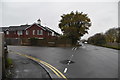
2
Junction with Bedfont Road
Northumberland Close junction with Bedfont Road
Image: © Shaun Ferguson
Taken: 15 Feb 2013
0.01 miles
3
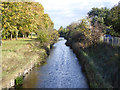
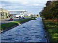
Longford River looking downstream
A 17th century artificial cut, here diverted around Heathrow Airport in recent times. It was to supply good water from the River Colne to Hampton Court.
Image: © Robin Webster
Taken: 22 Oct 2017
0.03 miles
4
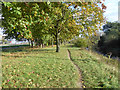
Path between rivers
The Duke of Northumberland's River is on the left. Lower, on the right, the Longford River. Both are here diverted around Heathrow Airport, although both were artificial rivers anyway. The Duke's 16th century river was to augment water supply for his mills by diverting water from the River Colne to the River Crane. The Longford River was dug in the 17th century to supply water to Hampton Court from the River Colne.
Image: © Robin Webster
Taken: 22 Oct 2017
0.04 miles
5
Duke of Northumberland's River
Looking downstream along the diversion of the original 16th century artificial cut around Heathrow Airport. It runs from the River Colne to the River Crane, and was to augment the water supply for the duke's mills. On the left is the Southern Perimeter Road of Heathrow Airport.
Image: © Robin Webster
Taken: 22 Oct 2017
0.06 miles
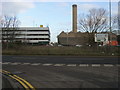
6
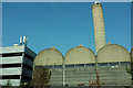
Building at Heathrow
By the Southern Perimeter Road near the Cargo Centre, with a tall chimney. On the left is a car park.
Image: © Derek Harper
Taken: 29 Mar 2019
0.07 miles
7
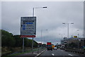
Southern Perimeter Road, Heathrow Airport
Image: © N Chadwick
Taken: 23 Aug 2010
0.07 miles
8
Car park, Heathrow Cargo Centre
By the Southern Perimeter Road.
Image: © Derek Harper
Taken: 29 Mar 2019
0.07 miles
9
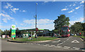
BP Garage, Bedfont Road
At the junction with Clare Road.
Image: © Des Blenkinsopp
Taken: 21 Aug 2015
0.09 miles
10

A truck leaves Heathrow cargo terminal
Visible are buildings for Etihad (possibly handled by Worldwide Flight Services), British Airways and Cathay Pacific.
Image: © Robin Webster
Taken: 22 Oct 2017
0.09 miles