IMAGES TAKEN NEAR TO
Hendon Way, STAINES-UPON-THAMES, TW19 7LH
Introduction
This page details the photographs taken nearby to Hendon Way, TW19 7LH by members of the Geograph project.
The Geograph project started in 2005 with the aim of publishing, organising and preserving representative images for every square kilometre of Great Britain, Ireland and the Isle of Man.

There are currently over 7.5m images from over14,400 individuals and you can help contribute to the project by visiting https://www.geograph.org.uk
Image Map
Images are licensed for reuse under creativecommons.org/licenses/by-sa/2.0
Notes
- Clicking on the map will re-center to the selected point.
- The higher the marker number, the further away the image location is from the centre of the postcode.
Image Listing (105 Images Found)
Images are licensed for reuse under creativecommons.org/licenses/by-sa/2.0
Image
Details
Distance
2
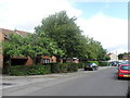
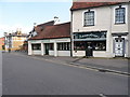
Bedfont Road, Stanwell
From the High Street mini-roundabout junction
Image: © David Howard
Taken: 26 Aug 2013
0.13 miles
3
Stanwell: 1833 milestone
This milestone is on the north side of the High Street opposite Image and has the inscription "MS 1833" on this side, and "London 15 miles" on the side facing the road. The far side inscription is completely worn away. It is a Grade II Listed structure.
Image: © Nigel Cox
Taken: 20 Jun 2010
0.13 miles
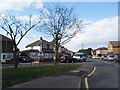
5
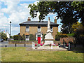
Stanwell War Memorial
A bit of a green and a few nice old houses near the church. A reminder that Stanwell was a village for centuries before London's suburbs caught up with it.
Image: © Des Blenkinsopp
Taken: 6 Jun 2019
0.13 miles
6
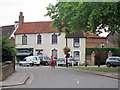
46 to 48 High Street
Grade II listed http://list.english-heritage.org.uk/resultsingle.aspx?uid=1204882
Image: © Oast House Archive
Taken: 6 Aug 2011
0.14 miles
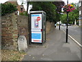
7
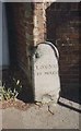
Old Milestone by High Street, Stanwell
Carved stone post by the UC road, in parish of Stanwell (Spelthorne District), High Street, opposite The Swan PH, West of junction with Oaks Road, in pavement, beside phone box, on North side of road. Erected by an unknown authority in the 19th century.
Inscription reads:-
: M.S. / 1833 : : LONDON / 15 MILES / (??) / (M)ILES) : : (RUIS)LP :
Grade II listed.
List Entry Number: 1204803 https://historicengland.org.uk/listing/the-list/list-entry/1204803
Milestone Society National ID: MX_L15
Image: © C Woodward
Taken: 23 Mar 2005
0.14 miles
8
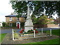
Stanwell War Memorial
At the centre of the old village of Stanwell and just north of the parish church is a small triangular green, surrounded by attractive houses. On it is the war memorial as seen here.
Image: © Marathon
Taken: 10 Sep 2014
0.14 miles
10
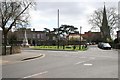
Stanwell
Dunmore House, St Mary's Church and War Memorial, Stanwell.
Image: © Brendan and Ruth McCartney
Taken: 25 Mar 2005
0.14 miles