IMAGES TAKEN NEAR TO
Douglas Road, STAINES-UPON-THAMES, TW19 7HD
Introduction
This page details the photographs taken nearby to Douglas Road, TW19 7HD by members of the Geograph project.
The Geograph project started in 2005 with the aim of publishing, organising and preserving representative images for every square kilometre of Great Britain, Ireland and the Isle of Man.

There are currently over 7.5m images from over14,400 individuals and you can help contribute to the project by visiting https://www.geograph.org.uk
Image Map
Images are licensed for reuse under creativecommons.org/licenses/by-sa/2.0
Notes
- Clicking on the map will re-center to the selected point.
- The higher the marker number, the further away the image location is from the centre of the postcode.
Image Listing (110 Images Found)
Images are licensed for reuse under creativecommons.org/licenses/by-sa/2.0
Image
Details
Distance
1
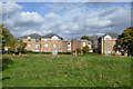
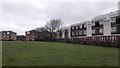
Housing estate, Stanwell
Largely low-rise flats.
Image: © Robin Webster
Taken: 22 Oct 2017
0.05 miles
2
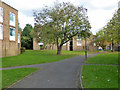
Path towards Whitley Close, Stanwell
In an estate of low-rise flats.
Image: © Robin Webster
Taken: 22 Oct 2017
0.07 miles
3
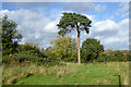
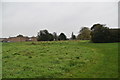
Pine tree, recreation ground, Stanwell
Image: © Robin Webster
Taken: 22 Oct 2017
0.08 miles
4
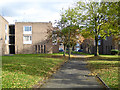
Path towards Whitley Close, Stanwell
In an estate of low-rise flats.
Image: © Robin Webster
Taken: 22 Oct 2017
0.09 miles
6
Bedfont Road, Stanwell
From the High Street mini-roundabout junction
Image: © David Howard
Taken: 26 Aug 2013
0.10 miles
9

Looking north-northeast in Whitley Close
(with Bristol Close on the left)
Image: © Basher Eyre
Taken: 12 Feb 2019
0.11 miles
10

Looking south-southwest along Whitley Close
(towards Falcon Drive)
Image: © Basher Eyre
Taken: 12 Feb 2019
0.11 miles