IMAGES TAKEN NEAR TO
Frobisher Crescent, STAINES-UPON-THAMES, TW19 7DU
Introduction
This page details the photographs taken nearby to Frobisher Crescent, TW19 7DU by members of the Geograph project.
The Geograph project started in 2005 with the aim of publishing, organising and preserving representative images for every square kilometre of Great Britain, Ireland and the Isle of Man.

There are currently over 7.5m images from over14,400 individuals and you can help contribute to the project by visiting https://www.geograph.org.uk
Image Map
Images are licensed for reuse under creativecommons.org/licenses/by-sa/2.0
Notes
- Clicking on the map will re-center to the selected point.
- The higher the marker number, the further away the image location is from the centre of the postcode.
Image Listing (18 Images Found)
Images are licensed for reuse under creativecommons.org/licenses/by-sa/2.0
Image
Details
Distance
1
Hadrian Way, Stanwell, TW19
Looking north near the junction with Clare Road. The housing is well set back.
Image: © Andrew Hill
Taken: 16 Jul 2008
0.13 miles
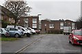
2
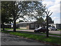
St. David's Health Centre in Stanwell, Middlesex
Image: © James Denham
Taken: 30 Aug 2010
0.16 miles
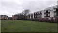
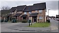
4
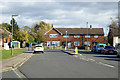
Houses on Clare Road, Stanwell
Looking from Falcon Drive.
Image: © Robin Webster
Taken: 22 Oct 2017
0.17 miles
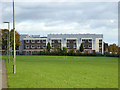
5
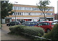
Trident House shop and office block
Clare Road, Stanwell, TW19.
Image: © Andrew Hill
Taken: 16 Jul 2008
0.17 miles
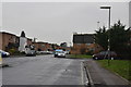
6
Lancaster Close - Stanwell
Falcon Road Junction with Lancaster Close.
Image: © James Emmans
Taken: 8 Apr 2016
0.18 miles
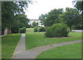
7
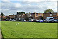
Housing on Falcon Drive, Stanwell
Black-headed gulls are on the grass.
Image: © Robin Webster
Taken: 22 Oct 2017
0.19 miles