IMAGES TAKEN NEAR TO
Town Lane, STAINES-UPON-THAMES, TW19 7BZ
Introduction
This page details the photographs taken nearby to Town Lane, TW19 7BZ by members of the Geograph project.
The Geograph project started in 2005 with the aim of publishing, organising and preserving representative images for every square kilometre of Great Britain, Ireland and the Isle of Man.

There are currently over 7.5m images from over14,400 individuals and you can help contribute to the project by visiting https://www.geograph.org.uk
Image Map
Images are licensed for reuse under creativecommons.org/licenses/by-sa/2.0
Notes
- Clicking on the map will re-center to the selected point.
- The higher the marker number, the further away the image location is from the centre of the postcode.
Image Listing (24 Images Found)
Images are licensed for reuse under creativecommons.org/licenses/by-sa/2.0
Image
Details
Distance
1
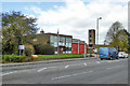
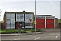
Staines Fire Station
Nearly opposite Tesco on Town Lane.
Image: © Robin Webster
Taken: 22 Oct 2017
0.02 miles


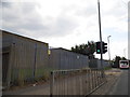
4
New block at Ashford Hospital
They have only just finished these blocks, around 2014
Image: © David Howard
Taken: 2 Nov 2014
0.04 miles

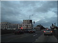
7
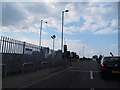
A Busy Crossroads
Stanwell Road meets Staines Road (A30).
Image: © Des Blenkinsopp
Taken: 15 Aug 2023
0.05 miles
8
Staines fire station
Staines fire station, Town Lane, Staines, Surrey
Image: © Kevin Hale
Taken: 12 Nov 2006
0.06 miles
9

Tesco Extra sign on the corner of Town Road
Image: © David Howard
Taken: 26 Aug 2013
0.06 miles
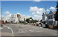
10
Stanwell Road at the junction of the A30
Image: © David Howard
Taken: 26 Aug 2013
0.07 miles