IMAGES TAKEN NEAR TO
Meadow View, Hithermoor Road, STAINES-UPON-THAMES, TW19 6BH
Introduction
This page details the photographs taken nearby to Meadow View, Hithermoor Road, TW19 6BH by members of the Geograph project.
The Geograph project started in 2005 with the aim of publishing, organising and preserving representative images for every square kilometre of Great Britain, Ireland and the Isle of Man.

There are currently over 7.5m images from over14,400 individuals and you can help contribute to the project by visiting https://www.geograph.org.uk
Image Map
Images are licensed for reuse under creativecommons.org/licenses/by-sa/2.0
Notes
- Clicking on the map will re-center to the selected point.
- The higher the marker number, the further away the image location is from the centre of the postcode.
Image Listing (50 Images Found)
Images are licensed for reuse under creativecommons.org/licenses/by-sa/2.0
Image
Details
Distance
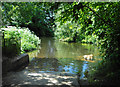
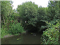
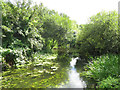
3
The River Colne north of Hithermoor Lake (2)
Image: © Mike Quinn
Taken: 8 Aug 2018
0.08 miles
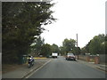
5
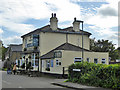
The Anchor, Stanwell Moor
At the junction of Horton Road and Hithermoor Road.
Image: © Robin Webster
Taken: 22 Oct 2017
0.09 miles
6

The Anchor, Stanwell Moor
At the junction of Horton Road and Hithermoor Road.
Image: © Robin Webster
Taken: 22 Oct 2017
0.09 miles
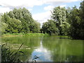
8
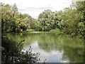
Hithermoor Lake
The lake is part of flood relief measures on the River Colne, and is fished by the Bath Road Piscatorial Society http://www.brps.co.uk/ .
Image: © Mike Quinn
Taken: 8 Aug 2018
0.09 miles