IMAGES TAKEN NEAR TO
Hithermoor Road, STAINES-UPON-THAMES, TW19 6AR
Introduction
This page details the photographs taken nearby to Hithermoor Road, TW19 6AR by members of the Geograph project.
The Geograph project started in 2005 with the aim of publishing, organising and preserving representative images for every square kilometre of Great Britain, Ireland and the Isle of Man.

There are currently over 7.5m images from over14,400 individuals and you can help contribute to the project by visiting https://www.geograph.org.uk
Image Map
Images are licensed for reuse under creativecommons.org/licenses/by-sa/2.0
Notes
- Clicking on the map will re-center to the selected point.
- The higher the marker number, the further away the image location is from the centre of the postcode.
Image Listing (50 Images Found)
Images are licensed for reuse under creativecommons.org/licenses/by-sa/2.0
Image
Details
Distance
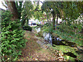
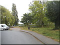
1
Hithermoor Road
In Stanwell Moor, with a significant stream following the road.
Image: © Hugh Venables
Taken: 2 Jan 2010
0.01 miles
2
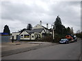
Stanwell Moor - Hethermoor Road
The Hope Inn is looking run down and neglected.
http://www.geograph.org.uk/photo/4008293
Image: © James Emmans
Taken: 1 Mar 2017
0.03 miles
3
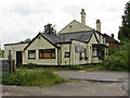
Former Hope Inn, Stanwell Moor
The derelict Hope Inn on Hithermoor Road.
Image: © Alan Hunt
Taken: 16 May 2014
0.03 miles
4
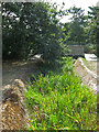
Ditch at corner of Hithermoor Road
This is part of the semi-natural drainage of the Stanwell Moor area, this is looking upstream. Behind the camera its route has been altered slightly consequent to the building of the King George VI Reservoir.
Image: © Robin Webster
Taken: 22 Oct 2017
0.05 miles
5
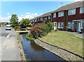
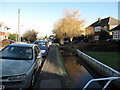
Stream along Hithermoor Road
Yet another watercourse in the maze of millstreams, diversions and alternative channels which make up the River Colne.
This stream appears to flow from the Longford River, itself a Colne distributary, back into the main river on Staines Moor.
Image: © Des Blenkinsopp
Taken: 6 Jun 2019
0.06 miles
6
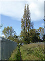
Footpath from Stanwell Moor Road to Hithermoor Road
A rather monotonous path along the fence of the King George VI Reservoir with little variety in views through the fence and a high hedge and bank most of the way blocking views to the north.
Image: © Robin Webster
Taken: 22 Oct 2017
0.06 miles
7
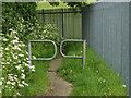
Path by King George VI reservoir
Barriers along the path that runs along the northern side of the King George VI reservoir.
Image: © Alan Hunt
Taken: 16 May 2014
0.07 miles
9
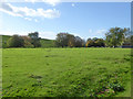
Grassland north of King George VI Reservoir
Within the reservoir property, grazed by sheep.
Image: © Robin Webster
Taken: 22 Oct 2017
0.08 miles